
Some of the more commonly asked questions we receive at VCGI share a theme in that they pertain to the status of a municipality’s parcel data. What date do these lines represent? When were they last updated? Who updated them, and how? When will they be updated again? This post clarifies the status of town parcel data published by the Vermont’s Statewide Parcel Program, while also displaying how to navigate the Town Parcel Mapping Status dashboard to learn the status of any town’s parcel data made available by the Program.
Before getting into the details of parcel data status, a recap of what parcel data are (and are not) is in order. Vermont municipal parcel data are just that—they are maintained by the towns themselves, typically with the help of a hired GIS map vendor. These data are voluntarily shared with VCGI for joining with the most recent annual statewide grand list published by the Tax Department and incorporation in statewide parcel data products that are used by multiple applications and serve many uses.
Town parcel geometry updates are shared, typically by their vendor, via the parcel data submission form when complete. As each town performs map updates at different times of the year, with different durations between updates, it is best to check the status of an individual town in question as their geometry is published by VCGI on a rolling basis as it is received. More detail about when parcel data are updated and published is available here.
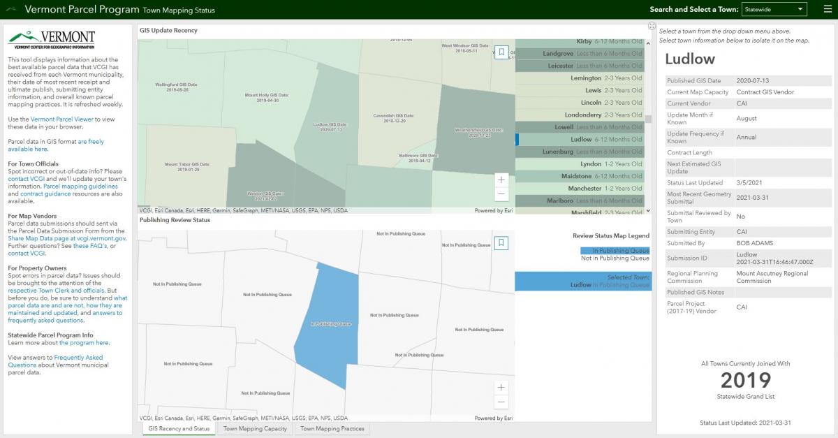 An example of a town (Ludlow) recently submitted to VCGI by the town’s map vendor and in the publishing queue, waiting for its geometry updates to be incorporated into the statewide parcel data products published by VCGI.
The Parcel Program's Town Mapping Status Dashboard
VCGI is in regular contact with towns to verify the status of their parcel mapping practices. This includes confirming a town’s current map capacity, or in other words, whether they have hired a GIS vendor or at least an entity that maintains parcel data digitally. We also ask about the town’s update frequency, or how often geometry updates are completed, be that annually, every other year, or longer. These factors and more are now reflected on a town by town basis on the Town Parcel Mapping Status Dashboard and are updated as we receive new information. Let’s look at how to use this tool.
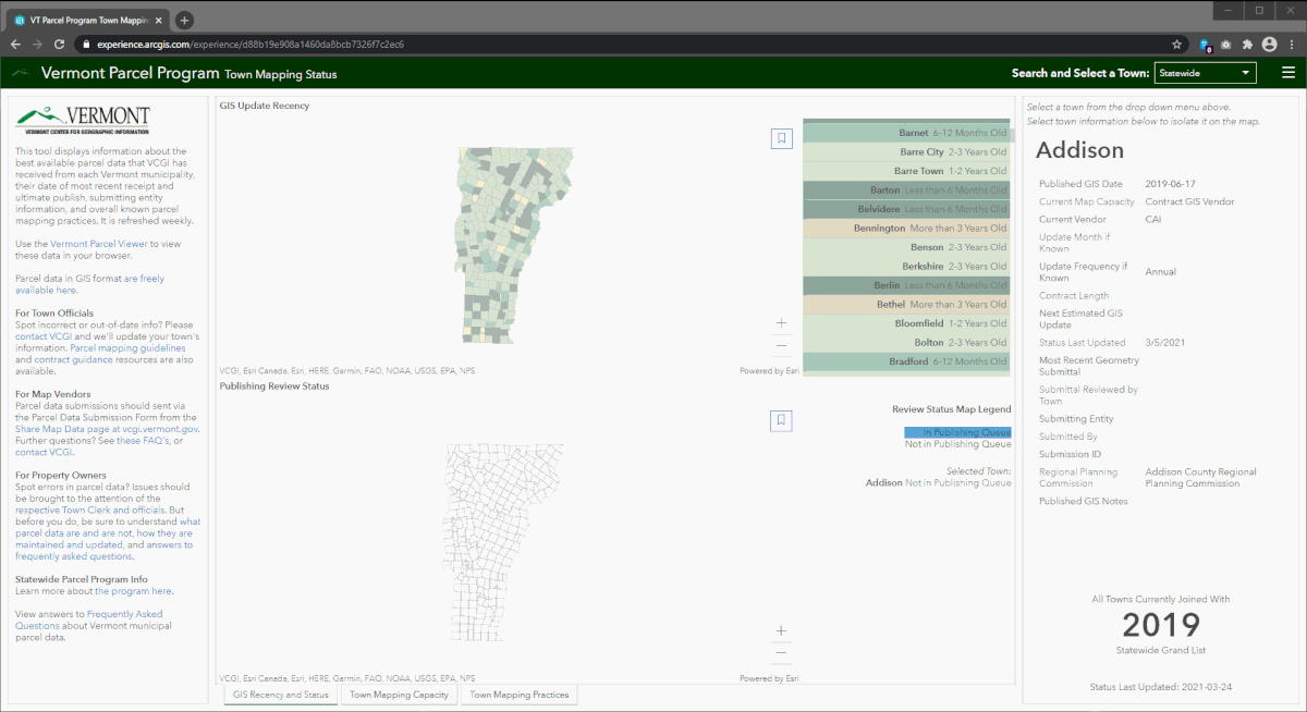
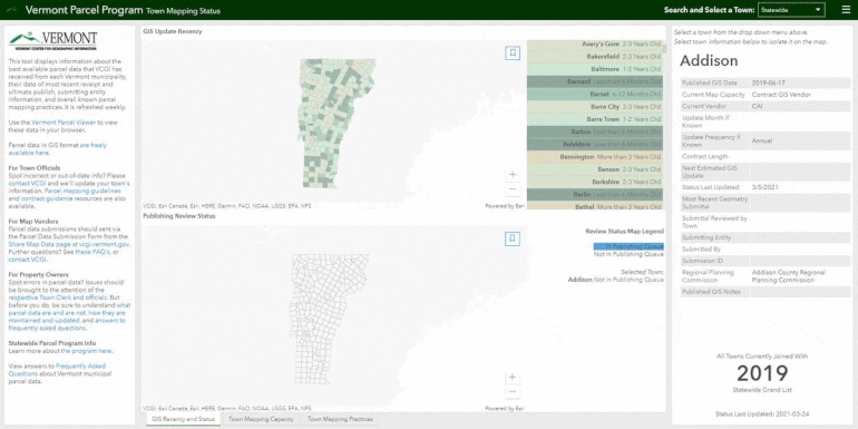 Navigating information in the dashboard involves selecting a town by either searching the pull-down menu in the top right or by clicking the town in the GIS Update Recency list. Different information may be displayed by selecting a tab along the bottom.
 A selected town’s information is held constant across the different tabs. For example, the animation above shows how to view the GIS update recency, town mapping capacity, and status details for the selected Town of Berlin. Be sure to deselect a town by clicking it once again, either in the pull-down menu or list to return to a statewide view.
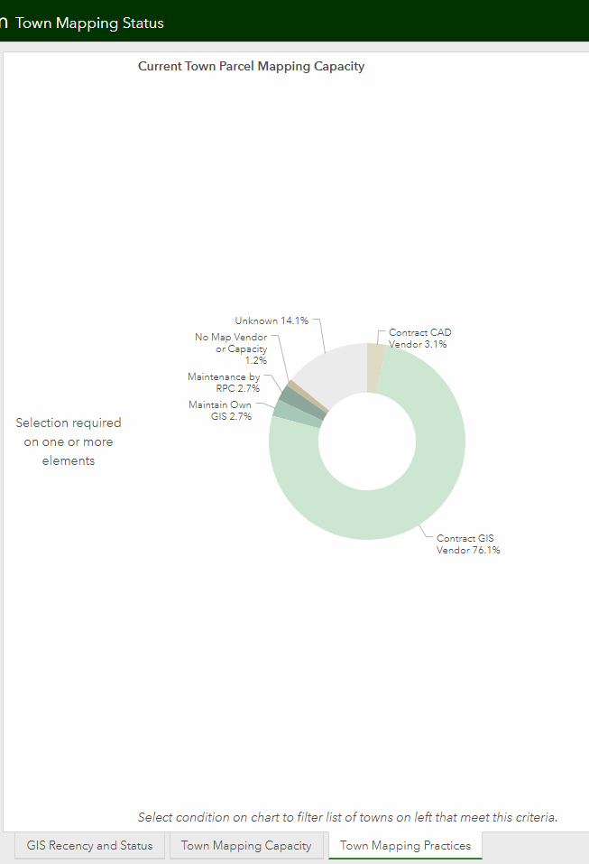 The Town Mapping Practices tab enables a statewide view of how towns address parcel data maintenance. The donut chart is selectable to view those towns associated with a known means of parcel map upkeep. This is helpful for understanding why your town’s geometry may not be as recent as you expect, or, if you are a town official, seeing how other towns perform maintenance while making sure yours is correctly represented in its practices.
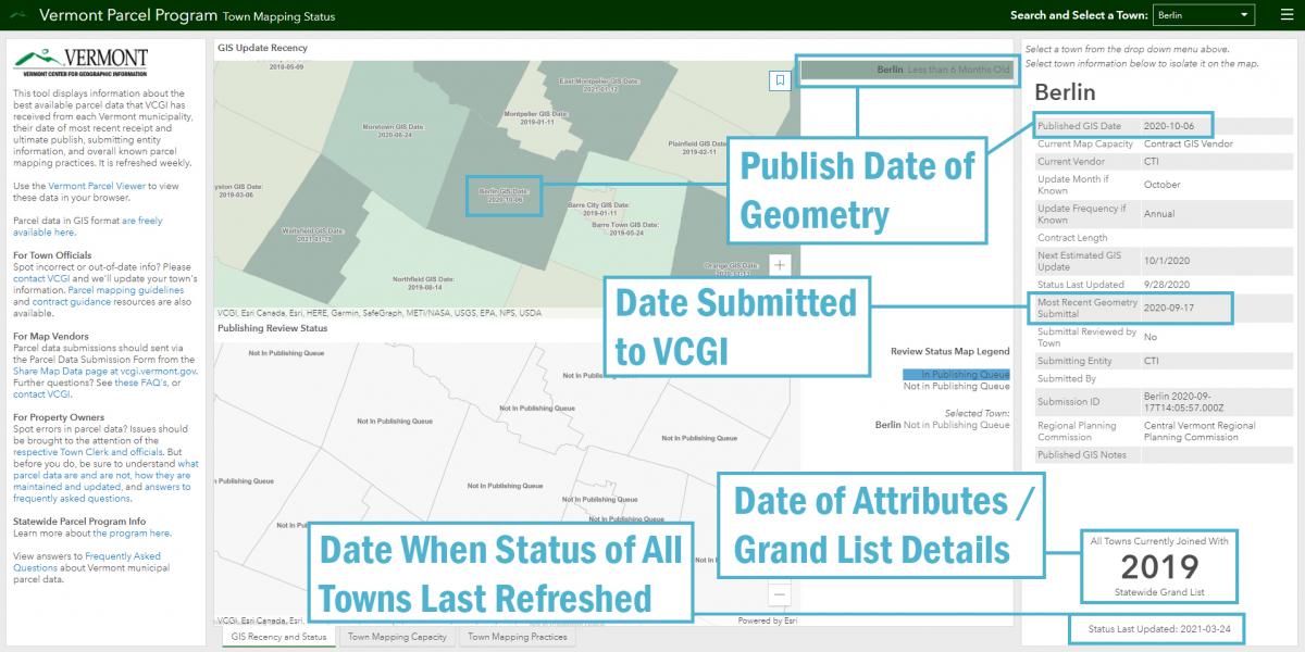
Dates of parcel data may be particularly confusing. As shown above, the Town Parcel Mapping Status dashboard displays multiple dates for a town. The dates that are likely of interest are the publish date of geometry (Published GIS Date) and date of attributes or grand list details. Vendors and municipal officials may also find the date of most recent geometry submitted to VCGI (Most Recent Geometry Submittal) and status refresh date helpful.
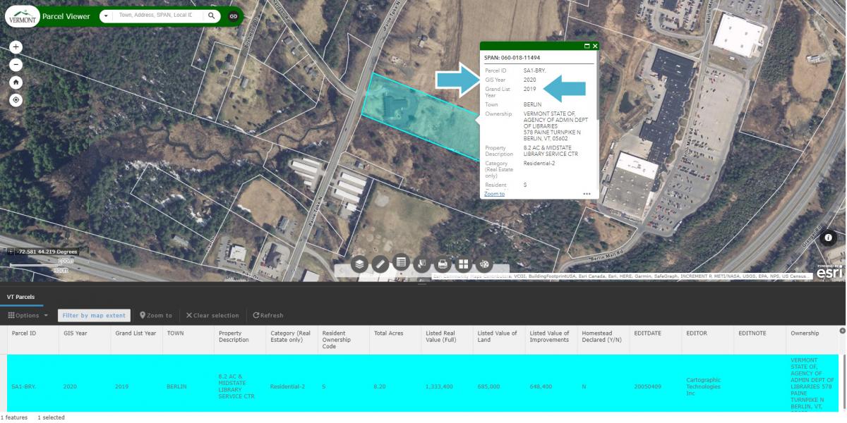
The published GIS date entry and date of grand list attributes correspond with GIS Year and Grand List Year within the parcel data itself, as shown below in our example with the Town of Berlin seen in the Vermont Parcel Viewer.
Keeping Status Current and Staying in the Know
Town officials should contact VCGI if they spot incorrect or out-of-date information about their town’s parcel mapping practices—we will be happy to update our records. The status dashboard will also be useful to make sure we at VCGI have received the most recent update of your town’s parcel data. For those towns currently without parcel mapping capacity, we also provide parcel mapping guidelines that include contract guidance to aid procurement and working with a digital map vendor. If you have any other questions regarding GIS parcel data in Vermont, please don’t hesitate to contact us.
Vendors may also continue to share parcel data updates via the Parcel Data Submission form available from the Share Map Data page at vcgi.vermont.gov. You will receive an email notification upon successful data submission and may also review the publishing queue and status of your submittals within the Town Mapping Status Dashboard. Further information about the parcel program for mapping professionals is also available in the parcel program FAQ’s.
Lastly, property owners who wonder how they might have their parcel data changed should hopefully now understand more about how parcel data are maintained by towns and published through the Parcel Program. The Town Mapping Status Dashboard is a tool to help one understand who is responsible for a town’s parcel data upkeep, at what frequency the town maintains it, when a new update may be expected, and when we at VCGI have received and published said town’s data within the statewide parcel products that display in applications such as the Vermont Parcel Viewer, ANR Atlas, e911 viewer, and more. Having this information in hand, coupled with an understanding of what parcel data are and are not aided by answers to frequently asked questions--including this one in particular--should help to clarify when it is ideal to reach out to your local town official about parcel data changes and improvements.
View the Vermont Town Parcel Mapping Status Dashboard here: https://maps.vcgi.vermont.gov/parcelstatus
View the best available parcel data published by the Parcel Program in the Vermont Parcel Viewer here: https://maps.vcgi.vermont.gov/parcelviewer
Learn more about the statewide Parcel Program here: https://vcgi.vermont.gov/data-and-programs/parcel-program
Access Vermont parcel data in GIS format here: https://geodata.vermont.gov/pages/parcels