Lidar
2023 Vermont Lidar Plan
The 2023 Vermont Lidar Plan charts a path towards a goal of Quality Level 1 lidar data collected statewide in the Spring of 2023 during leaf-off conditions.
Finding and Using Vermont Lidar Data: An Introduction (2022)
Interested in finding and using freely available Vermont lidar-derived elevation data products, perhaps for the first time? This webinar hosted by the Vermont Center for Geographic Information (VCGI) covers how to find and understand lidar-derived data, with emphasis on web browser-based tools to view them. We will cover data products made available by VCGI’s lidar program, and the VT Interactive Map Viewer as a means of access. Video recording is available here: https://youtu.be/XXiyHsa3D7Q
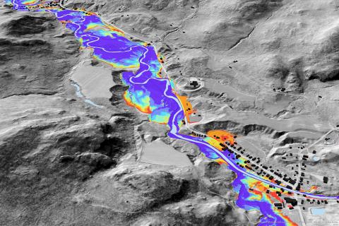
Topographically-defined Floodplains: Relative inundation for conservation and restoration planning in the Lake Champlain Basin, Vermont
The Topographically-defined Floodplains were generated from high-resolution topographic data along rivers draining greater than 2 square miles in the Vermont portion of the Lake Champlain Basin. These floodplains are intended for planning and research use by government, academic, commercial and non-governmental agencies; they are not a substitute for FEMA Flood Insurance Rate Maps and are not intended for regulatory use. A greater geospatial coverage of floodplains in the basin will support analyses of floodplain and wetland processes and restoration and conservation planning for improved water quality, enhanced flood and climate resilience, and expanded habitat and ecosystem functions. Lateral extents of flooding for storms of recurrence intervals ranging from 2 to 500 years are represented in the dataset.