- What is aerial orthoimagery?
- What is the Vermont Imagery Program (VIP)?
- How often is imagery updated?
- In what types and formats are orthoimagery made available?
- How can I view orthoimagery made available by VIP?
- Where can I find historical Vermont aerial imagery?
- What are the differences between imagery data and imagery services?
- What is different about imagery collected and published by the program relative to other web map imagery?
- What are the differences in compressed and uncompressed files?
- How do I find out the date in which a specific image was taken?
- How do I find out what dates and types of imagery are available for a location?
- How do I obtain the coordinates for a point on the image?
- How do I obtain the tile number of a particular imagery tile?
- How do I measure an area and export it as a shapefile?
- Can orthoimagery be combined with other map data?
General
What is aerial orthoimagery?
Digital aerial orthoimagery are photos that have been georectified and georeferenced and thus are useful representations of the earth's surface at a point in time.
What is the Vermont Imagery Program (VIP)?
VCGI's Imagery Program oversees the collection and provisioning of high resolution, freely available georeferenced orthoimagery and other remotely sensed products throughout Vermont. Originally started in the 1970's with the collection of analog aerial photography, the collection of digital, rectified and georeferenced orthoimagery began in 1994.
How often is imagery updated?
Typically once a year for a portion of the state. New imagery is collected annually for select portions of Vermont, with the entire state set to be updated over a five-year period called a "vintage". The general window for capturing orthoimagery is during the spring after the snowmelt, and before the deciduous trees "leaf-out" so as to provide a view of the surface unobstructed by leaves and without long shadows. As you can imagine given Vermont weather, this sometimes makes capturing imagery a challenge. These data are then processed and typically published later that year. Notifications of published updates are made on numerous channels, including the news and updates section of this site, and more. An overview of the extents of the current vintage is here.
In what types and formats are orthoimagery made available?
Georeferenced orthoimagery collected and made available by the program now include 4-band color and color infrared, as well as black and white. Imagery is provided in both Web Mercator (WM) and Vermont State Plane Meters (SP) (EPSG:32145) projections for web services, and in Vermont State Plane Meters (SP) (EPSG:32145) for downloads. Older collections include composite color infrared, and 3-band color. For an example of these types taken at the same location, see the image below:

Imagery is provided as a JPEG2000 (.jp2) filetype at 1:18 compression ratio to maintain a useful quaility while reducing file size, all while retaining georeference information.
How can I view orthoimagery made available by VIP?
Imagery is available in multiple ways:
- As downloadable data served both in individual tiles (small sections of the entire collection) and batch downloads of an entire collection at the imagery page on the Vermont Open Geodata Portal (a sortable table-based way of finding what's available)
- As downloadable data served both in individual tiles (small sections of the entire collection) and batch downloads of an entire collection at the Vermont Orthoimagery Finder web application (a map-based way of finding what's available)
- As streaming services for desktop and online use at links from the imagery page on the Vermont Open Geodata Portal
- As a layer that can be turned on and off in web mapping applications such as the Vermont Interactive Map Viewer, ANR Atlas, and e911 viewers, to name a few.
Where can I find historical Vermont aerial imagery?
VCGI obtains and publishes Vermont aerial imagery taken prior to 1994 as time and resources permit. Some of these converted-to-digital collections are published as georeferenced imagery, others are not. Available digital aerial and orthoimagery are listed and downloadable at the imagery page on the Vermont Open Geodata Portal. See the sortable data catalog table under the datasets section, and sort by year.
Please note that not all Vermont historical imagery has been digitized and made available to VCGI for publishing. For historical aerial imagery collections that remain analog-only, please visit the Vermont State Archives & Records Administration (VSARA) in Middlesex to access these documents. A list of VSARA's imagery holdings is also viewable online by searching the Guide for "aerial" or "imagery". Current non-digitized collections not entirely available from VCGI include:
- Vermont Tax Mapping Program aerial photographs, orthophotographs, and films, 1945 - 2010. Item Series ID: PVRD-002
- Vermont Department of Highways, Aerial Photographs, 1952-1967. Item Series ID: HG-002
- Vermont Department of Forests, Parks and Recreation, Aerial Photographs, 1942-1966. Item Series ID: FPR-004
- Vermont Agency of Transportation, Aerial Photographs (Glass Negatives), circa 1960's - 1971. Item Series ID: A-080
- VSARA, Fairchild Aerial Surveys, Inc.: oblique aerial view of Vermont locations, 1946 - 1951. Item Series ID: A-361
What are the differences between imagery data and imagery services?
Put simply, they differ mostly in their intended uses--the data is the same. Imagery datasets are slightly less compressed, and serve well for advanced raster analysis. Services are handy when you want to have large geographic areas displayed without downloading many different tiles/collections, or don't have a need for analysis of the imagery.
What is different about imagery collected and provided by the program relative to other web map imagery?
There are a number of differences, but here are a few key ones:
Leaf Off vs. Leaf On. Imagery collected and provided by the VIP is taken at a time of year when the leaves are off, shadows are reasonable and thus they enable a visual representation of the ground beneath the deciduous tree canopy. This "leaf-off" imagery can be combined by type and with other "leaf-on" imagery (e.g. NAIP) for understanding differences in vegetation, for example.
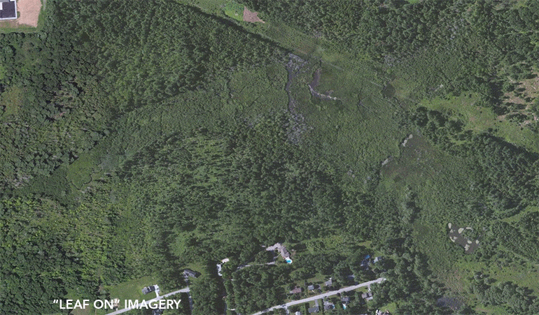
A comparison of leaf on imagery common in web map applications with leaf off imagery that is collected and published by the Vermont Imagery Program in color and color infrared.
Spatial Accuracy. Imagery collected by the program has fine tolerances for spatial accuracy, enabling better integration with other map data.

A comparison of imagery common in web map applications with VIP imagery shows differences in road alignments.
Availability in the VT State Coordinate System. Orthoimagery collected and published by the imagery program is available in the Vermont State Plane Meters (SP) (EPSG:32145) coordinate system, enabling it to be used with other VT map datasets.
Free Public Use. Imagery collected and published by VIP is freely available to the public and unrestricted in use.
What are the differences in compressed and uncompressed files?
Although data downloads are compressed JPEG2000's for reduced file size, the effects are negligible when compared with uncompressed GeoTIFF's that are orders of magnitude larger files.

How do I find out the date in which a specific image was taken?
Imagery collected by the program has the date taken in the file name of each respective tile. For example:

The "20180424" in the file name follows a YYYY/MM/DD format. The image in this example tile was taken on April 24, 2018. Tiles are available for their respective collection linked from the VT Orthoimagery Finder, and from the Imagery page at the VT Open Geodata Portal.
How do I find out what dates and types of imagery are available for a location?
The Vermont Orthoimagery Finder presents all available digital, georeferenced imagery going back to 1994 for locations throughout the state. It is a map-based view of seeing what is available where, in what types, and when they were taken.
How do I obtain the coordinates for a point on the image?
You can use the X,Y tools in desktop GIS platforms, but for most users a web mapping application such as the Vermont Interactive Map Viewer is a way to do this. See the images below for reference:

Quick, dirty, inexact way - Useful for when there is no other geometry overlaid on image to snap to:
Under the layer "All Imagery" in the left-hand layer list, there is a sub-layer for "Indexes". These are the bounds of the respective image tiles per each collection. If you toggle on this index layer by clicking the checkbox, and then right-click on a location in the map window, a set of X,Y coordinates displays in the popup window. These values reflect the location clicked with your cursor, and display the X,Y values of the corresponding coordinate system in the bottom left hand of the map window (32145: State Plane Meters in the example above). Be sure to set this to your respective coordinate system of interest to obtain the associated X,Y values.

Exact coordinates - Useful for when there is another layer with geometry to snap to, e.g. parcels:
Referring to the image above, the "Measure" tab has a tool called "Plot Coordinates". This tool allows you to set a coordinate system (e.g. EPSG:32145 Vermont State Plane Meters) that will display the values of selected X,Y points that "snap" to another layer's geometry. These snappable other layers can be set by the highlighted "Select Snapping Layers" button, and then choosing the respective layer with linework to snap to. (In the above example, parcel polygons under the "Standardized Parcels" layer is set as a snapping layer.) Once snapping layer(s) are set, you can click on intersection points such as corners on the map window, and a respective X,Y value will display on the left-hand side (and in the map window) in the values of the selected coordinate system. More than one point's coordinates can be determined by clicking on the map at more intersecting locations / corners of linework (e.g. the 2, 3, 4 in the above example).
How do I obtain the tile number of a particular imagery tile?
One way is to use the respective index layer of an available imagery collection for your location of interest, as in the example above using the VT Interactive Map Viewer. In that example, the selected tile colored in yellow is from the 2015 (0.5m) collection that is available for that area, and the TILENUM field displays 096044 as the tile number. These layers and their fields can be viewed in the attribute table at the bottom of the browser window by right-clicking in the map window, selecting "Find data on the map", and then selecting the appropriate tab of the respective index layer (the "Index 2015 (0.5m)" tab in the above example). For advanced users, web services of index layers are also available here.
In general, the file naming convention used for imagery tiles includes the tile number. For example, when viewing/downloading a tile from a collection as published at the imagery page at the VT Open Geodata Portal, the tile number appears both within the pop up and the file name as highlighted below:


How do I measure an area and export as a shapefile?
Using the measurement tool and snapping to parcel polygons as in this FAQ, one can also export the measured area as a shapefile for GIS use elsewhere using the "Export Drawings" feature. Note: the exported shapefile will be in a WGS 1984 / Web Mercator coordinate system and may need to be converted to another coordinate system (e.g., VT State Plane Meters) for other uses. See the animation below once a desired measured area (polygon) is complete:

How can imagery be combined with other map data?
Yes!
GIS is built on the use of many layers of mapped information, and orthoimagery is a foundational layer. Imagery can also be used in creative ways, such as to hint at surface cover when combined transparently with other layers such as lidar-derived contours and hillshade as in the image below:
