How do I find Vermont GIS data?
All free and publicly available Vermont-specific GIS datasets are hosted at the Vermont Open Geodata Portal. VCGI oversees the portal, with partner agencies, departments, and organizations publishing their respective datasets there as well. You may search the VT Open Geodata Portal by theme, search term, publishing organization, dataset type, and more. Overview videos of the Open Geodata Portal are available here. A broad overview of available Vermont GIS data (as of 2022) is also available here, and another here.
In which coordinate systems are VT GIS data provided?
GIS data at the VT Open Geodata Portal are provided in one or two coordinate systems:
- Vermont State Plane Meters (EPSG: 32145) (learn more here)
- Web Mercator (EPSG: 4326) (used for latitude / longitude applications) or EPSG:3857 WGS84/Pseudo-Mercator (learn more here). These are useful for web mapping applications.
The Vermont State Plane Coordinate System is the State of Vermont's official coordinate system. You can read more about Vermont's Coordinate System in statute here (Title 1, Chapter 17 § 671- 679). *Note: There are details beyond the basic NAD 1983 classification, if it becomes an issue in your work give us a call.
In 2022, the National Geodetic Survey is leading the replacement of the North American Datum of 1983 (NAD 83) (on which the current Vermont State Plane Meters system is based) and the North American Vertical Datum of 1988 (NAVD 88) with a new geometric reference frame and geopotential datum. Learn more about this significant update here, and read notes about getting prepared for this datum change here.
How do I connect to web services?
Desktop GIS programs:
Video: Downloading and Connecting to Data and Services at the Vermont Open Geodata Portal (services content starts at ~18:00 minute mark)
Video: Connecting to VCGI Web Services in ArcGIS and QGIS
Video: Connecting to VT Geodata Web Services (ArcGIS Pro)
PDF (overview that includes reference to web services): Accessing GIS Resources at the Vermont Open Geodata Portal (2022)
Online Map Viewers:
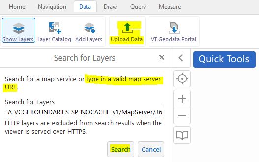
Services can also be added to online map viewers such as the Vermont Interactive Map Viewer via the "Upload Data" function under the Data tab:
How do I use Vermont Geocoding Services?
Geocoding is the process of converting addresses to display their geographic locations on a map. A geocoder such as the VT Geocoding Service enables this conversion by matching known input addresses with their respective point locations on a map.
Refer to this page for instructions on how to use Vermont's Geocoding Service, which is regularly updated with address information from the Vermont Enhanced 9-1-1 system (E911), specifically address points and road centerlines.
How do I use online map viewers such as the Vermont Interactive Map Viewer?
The software platform that runs the Vermont Interactive Map Viewer, ANR's Atlas and Atlas Lite, DHCD's Planning Atlas, and Enhanced 9-1-1 Board's e-9-1-1 viewer is the same. While these online map applications look different and load different layers by default, their functionality is largely the same.
That said, a number of how-to videos of current and earlier versions of these viewers are online. Again, these are largely applicable across these map applications.
Logging In and Saving/Loading Projects
VT Interactive Map Viewer Intro (older)
While not based on Vermont applications and with slightly different tools and data, other tutorials of this same platform are also helpful and relevant, such as this one.