- What are parcel data?
- Who is responsible for creating and maintaining parcel data?
- What was the statewide property parcel mapping project?
- Why are standardized digital parcel data useful?
- How was the statewide property parcel mapping project funded?
- What was funded by the project?
- What was not included in the project?
- How did the project work?
- What was the project's timeline?
- Who oversees the project?
- What is the difference between the parcel project and parcel program?
- Are parcel data considered a legal field survey?
- If parcel data are only a reference, how do I obtain a legal plat of land?
- What are the differences between "standardized" and "non-standardized" parcel data?
- Are parcel data updated in real-time?
- When are parcel data updated?
- How can I access and view Vermont parcel data?
- How can I learn how my town maintains its parcel data?
- How can I have my property's information or parcel lines changed in how they appear in State of Vermont data and applications?
- How do I measure a parcel's GIS acreage?
- What can standardized, grand list-joined digital parcel data be used for?
- How will the initial 3-year (2017-2019) parcel mapping project affect my town?
- Did municipal officials have the chance to review the parcel project data before it was published?
- What should a town look for when reviewing data?
- What should a town do once they have gone through the parcel mapping project?
- What is the longer-term plan for maintaining digital parcel data?
- What is the VT GIS digital parcel data standard?
- What is the difference between an "active" and "inactive" parcel?
- How can map vendors participate in the ongoing parcel maintenance program?
- How do map vendors submit parcel geometry updates to VCGI to include in the statewide layer?
- Who can we ask further questions?
General
What are parcel data?
Parcel data are not a survey but rather a map index of property ownership. They consists of property ownership information (Grand List) joined with mapped property boundaries. Digital parcel data are easily distributed, are searchable and can be analyzed and applied for other uses.
Who is responsible for creating and maintaining parcel data?
Parcel mapping is undertaken and overseen by, and is ultimately the responsibility of each Vermont municipality, who may perform map updates on their own or hire vendors to do so. The Tax Department suggests that this should occur at least annually. VCGI does not create or maintain parcel data but instead coordinates the collection of the best available digital parcel data from municipalities in GIS format and publishes that as both a statewide layer and one for each municipality. VCGI also develops the data standards by which digital GIS parcel data is organized and managed.
In short, the parcel data published by VCGI is the best information made available to us from municipalities, and questions regarding its currentness, qualities or details should ultimately be directed to the respective town clerk. The Secretary of State maintains a list of town clerks at this page.
What was the statewide property parcel mapping project?
As property ownership is public information, between 2017-2019 the project focused on making public parcel data that is collected and overseen by individual municipalities more accessible and useful across the state. The project also specified the digital standard for all of Vermont's municipal property records to be matched with the Grand List. It created baseline data for all Vermont municipalities that the ongoing Parcel Program will build upon.
Why are standardized digital parcel data useful?
Clarifying who owns what lands where aids fair and accurate taxation, the provisioning of public services, community decision-making, real estate development, guiding and assessing public investments, land and resource conservation, and more. Parcel data in Vermont prior to the standardization project was uneven in quality, coverage, age, availability, and ease of use. Today, information about land ownership and value is key to many public and private functions: regional planning, transportation planning and construction, state analysis of settlement patterns, taxation equity, and the impact of state programs, just to name a few. All of these tasks are made easier and more effective by ensuring that parcel data is joined with the annual grand list.
How was the statewide property parcel mapping project funded?
The initial 3 year project (2017-2019) to join all Vermont municipalities' parcel data with the grand list is funded 80% by Federal Highway funds, and 20% by a match provided by numerous state agencies and departments.
What was funded by the project?
The project funded one annual update to digital parcel data per each Vermont municipality to bring it in compliance with the digital parcel data standard, which put simply, uses the SPAN as a unique identfier for all parcels in Vermont to join said parcels with the annual grand list. The following activities performed by a GIS mapping vendor were awarded to each municipality through a competitive bidding process and were funded by the project:
- Communication with town officials and staff to gain a clear understanding of land records
- Land Record Research
- Scanning existing land records and maps
- Acquisition of existing parcel data
- In towns where no digital parcel data exists, the creation of that data
- Updating parcel data based on information gathered from town officials and supporting land records for that respective grand list year
- Creating an Extract, Transform, Load (ETL) tool which will convert the community’s existing data to meet the State standard if the community does not maintain their data in the State Standard. This tool will be provided to the State by each vendor as a deliverable and will be available to the community for future data conversion.
- Any transformation of data into the format required (GIS) for the state project using an ETL tool. Example: Converting CAD to GIS format
- Communication with town officials to verify SPAN information and additional edits to achieve a 99% match of the Grand List records to the digital parcel data layer
What was not included in the statewide property parcel mapping project?
The parcel project did not include:
- the cartographic development or update of tax parcel maps, whether they are paper or online (e.g. adding annotations, labels, symbolizing, etc.)
- the development or annual payment for online parcel mapping application for a town
- surveying for new linework
- verifying the precise spatial location or accuracy of existing linework
- providing access to existing surveys
- unifying different town mapping practices (for public rights-of-way and contiguous ownership, for example)
- reconciliation of mineral rights with at-grade ownership (e.g. two deeds assigned for the same parcel)
- resolving town boundary discrepancies
We expect that some of these items may be improved in the future as a result of the three-year project, but they remain longer-term challenges with the upkeep of standardized parcel data that remains current, reliable, comprehensive, and ultimately, useful.
How did the project work?
The Agency of Transportation (AOT) hired a number of mapping contractors (see list here) to update or create digital parcel data for all of the municipalities in Vermont in three phases over a 3-year period. Only contractors who met AOT’s eligibility criteria were approved to work on this project. The criteria included, but was not limited to, capacity to provide data products that meet the VT Parcel Data Standard.
Each contractor was assigned by AOT to a town through a competitive bid process to do their parcel data development and the decision as to which towns they work in will take into consideration town preferences. Towns that had a preference for their contractor from the approved list communicated that interest to VCGI.
AOT payed the contractors directly for the work required by the project. This was not a grant or reimbursement project. Towns may have set up separate contracts with the mapping contractor of their choice to purchase additional products like paper maps and custom online maps if they wish also have those services provided. The cost for the additional products should be lower than usual due to the work paid for by the project, as there is some overlap in records research for parcel updates, for example.
What was the project's timeline?
- 10 Mapping Companies were contracted to work on this project during September of 2017.
- Companies were assigned to phase 1 towns in November of 2017.
- 73 municipalities were completed with updated or newly created parcel data by mid-2018. These towns' parcel data is joined with the 2017 Grand List.
- 103 municipalities are assigned to phase 2 that began in August 2018 and are expected to be complete by the end of March 2018. These towns' parcel data are joined with the 2018 Grand List.
- The remaining 79 municipalities were assigned to phase 3 running from April 2019 through November 2019. These towns' parcel data are joined with the 2018 Grand List.
- All 255 Vermont municipalities (including Gores, Grants, and unincorporated towns) now have standardized, grand-list joined parcel data available as of December 2019, thus concluding the project stage of longer-term parcel program.
- An up to date map view of which towns are placed within which phase is viewable here.
- An up to date map view of which contractors worked with which town is viewable here.
- The standardized, grand list-joined parcel data for completed towns is available to view in the statewide parcels viewer, and in the geodata portal as both datasets and web services. These data are published on a rolling basis after they are checked for quality, adherence to the parcel data standard, and are reviewed by the municipality.
Who oversees the parcels project?
The Property Parcel Advisory Board established by 19 V.S.A. §44. The Board is comprised of the Secretary of Transportation or designee, the Secretary of Natural Resources or designee; the Secretary of Commerce and Community Development or designee; the Commissioner of Taxes or designee; a representative of the Vermont Association of Planning and Development Agencies; a representative of the Vermont League of Cities and Towns; and a land surveyor licensed under 26 V.S.A. chapter 45 designated by the Vermont Society of Land Surveyors.
What is the difference between the parcel project and parcel program?
The parcel “project” refers to the one-time-per-town state funding made available to vendors for GIS parcel data creation or update between 2017 and 2019 as administered by VTrans for every Vermont municipality. The project is complete as of December 2019.
The parcel “program” refers to the ongoing maintenance effort for publishing grand list-joined municipal parcel data in Vermont beyond the project and beginning in statewide grand list year 2019. The parcel program is overseen by VCGI. The goal of the program is to continue to make current and reliable grand list-joined parcel data available in GIS format for every town in Vermont.
Unlike the project, there is no state funding available for payments to vendors for GIS mapping services as part of the parcel program. Contracts for map products and services are the responsibility of each municipality.
VCGI will work directly with map vendors and towns who maintain their own data to procure parcel data updates as they are completed. VCGI's guidance document for working with map vendors and parcel data maintainers is here.
Are parcel data considered a legal field survey?
No. Parcels are a representation of property boundaries. They should not be used for property line disputes. A survey from a licensed land surveyor is the legal means of determining property boundaries. This is why applications such as the parcel viewer come with a disclaimer, which is worth restating here: Parcel data is general in nature and does not represent survey grade boundary information. Substantial inaccuracies in boundary lines or grand list attributes should be brought to the attention of the appropriate Town Clerk. While in some instances parcel data may reflect survey information, the recorded, signed and sealed survey that is filed with a town clerk remains the authoritative document.
If parcel data are only a reference, how do I obtain a legal plat of land?
Deeds and plats are available through the respective town clerk of the municipality in which the parcel is located. The Secretary of State maintains a list of town clerks available from this page. New surveys may be obtained by hiring a licensed surveyor. The Vermont Society of Land Surveyors maintains a list and map of survey professionals in Vermont.
What are the differences between "standardized" and "non-standardized" parcel data?
The short answer is that standardized parcel data in Vermont is joined with an annual grand list. Non-standardized data, the norm of parcel data before 2017, is highly varied in the information it contains, its coverage across the state, and is not joined with an annual grand list. The long (and more technical) answer is provided in the VT parcel data standard (v2.3), which is a GIS data standard adopted in 2016 and put to use from 2017-onward throughout Vermont by the Statewide Parcel Property Mapping project. As of December 2019, all nonstandardized data has been updated and is "standardized" for all Vermont municipalities.
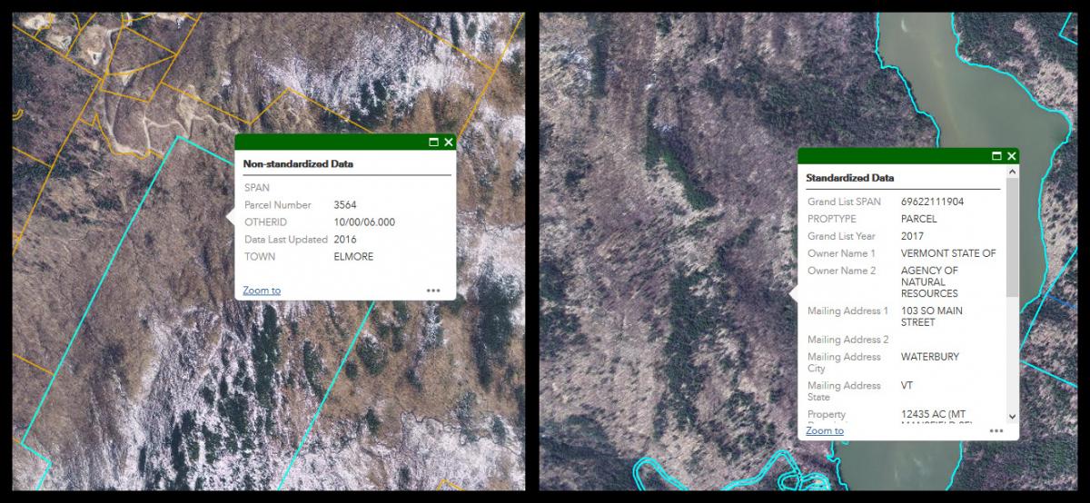
An example of "non-standardized" parcel data on the left, and "standardized" on the right. Parcel "standardization" involves making uniform the attributes associated with parcel map information such that they can be joined with the Grand List via SPAN.
When are parcel data updated?
The short answer:
- Parcel geometry are updated for each town after they are received by VCGI from their updating entity, typically a vendor hired by the town
- Parcel grand list attributes are updated for all towns once every year. This update reflects the most recent available annual grand list published by the Tax Department, typically in late Spring.
The longer answer:
Municipal parcel data in Vermont are subject to different maintenance and update cycles for each town. Some municipalities contract with a GIS vendor for annual map updates, whereas others only update their map information every 2-3 years. Some towns do not perform regular map updates.
Yet for all towns the grand list table—or “attribute” information such as ownership that is associated with a parcel’s geometry—is maintained throughout the year by the town and submitted once every year to the Tax Department. The Tax Department compiles the municipal grand lists and publishes a statewide composite grand list once a year, typically each Spring, representing the previous year’s “final” grand list. For example, the 2020 grand list attribute join reflects ownership as of April 1, 2020--not the entire calendar year of 2020 or transfers made after that date. It is this snapshot, most-recently-available statewide grand list that is joined by VCGI with parcel data from towns and published by the program.
Parcel data made available by the statewide parcel program thus involves 2 dates:
- Date of parcel geometry (GIS Date)
- Date of grand list attributes (Grand List Date)
Updates to grand list attributes are the most straightforward. Every year, once a year, VCGI will join all the most recent parcel map geometry with the most recent statewide grand list table as published by the Tax Department. This join is made via a parcel’s unique SPAN. This update occurs shortly after the statewide grand list is available from Tax. Changes that occur to the local grand list between annual statewide updates, such as ownership, are not reflected in the parcel data until a new annual statewide grand list is made available by Tax. This serves as another reminder that parcel data made available by the program are for reference, and it may be necessary to check with a town in question for current parcel status.
Regarding updates to parcel geometry, an individual town is updated after its map updates are received by VCGI from their updating entity, which is often a GIS vendor hired by the municipality. The speed at which these updates are published is dependent on how closely the data provided follows the digital parcel data standard, as all data published by VCGI will meet this standard. Individual town updates are then joined by VCGI with the most recently available statewide grand list. If there is updated geometry in a town that is more recent than the latest statewide grand list, those parcels are displayed on the map, but will be unmatched with grand list information until the next year’s statewide grand list is available and joined. In these cases, data providers can note parcels that are intended to be matched to the next grand list upon submittal to VCGI. The date of receipt of geometry updates from the updating entity is also noted for each town in the data, to document which geometry updates can be expected to be reflected in the data.
For towns that do not perform regular map updates, they too are joined by VCGI with each annual statewide grand list update. This updates the grand list information of those parcels VCGI has with SPAN information. Updates to these towns’ geometry, however, is dependent on a digital survey of any boundary line change within said town being available in the Vermont Land Survey Library. VCGI checks the Land Survey Library for any documented line changes and will include them in the parcel geometry for those towns who do not perform regular map updates as time allows after the annual grand list has been published. This may not capture all geometry updates that have occurred in a town, and is why VCGI advises all towns to work with a GIS vendor to ensure the most accurate and regular documentation of parcels in their municipality.
Are parcel data updated in real-time?
No. Parcel data are not real-time or reflective of immediate changes in either geometry or grand list attributes. There is a delay between a property transfer, its recording in a statewide grand list published by the Tax Department, changes in a town's parcel map geometry, our receipt of said data, its review for meeting the statewide parcel data standard, and ultimately its publishing within the parcel dataset as joined to the most currently available statewide grand list. Parcel data is at best a starting point and guide to further information. When in doubt, please refer to both a ground survey and your town clerk for confirmation of the best and most currently available geometry and/or ownership information for a specific location.
For Users
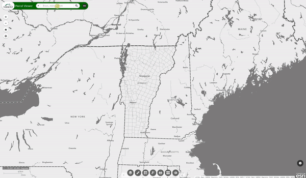
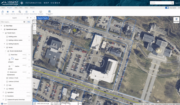
How can I access and view Vermont parcel data?
The most direct way to view parcel data is within the Vermont Parcel Viewer web mapping application. This tool allows you to interact with the most current parcel data we have for each municipality across the state directly in your web browser. It contains features such as search by SPAN or address, and looking up associated grand list information. It also specifies the year of the annual grand list join of the currently available data for each town.
 A screenshot of the Vermont Parcel Viewer, a web browser based mapping application that allows a user to view and interact with the best available parcel data available from VCGI.
The Parcel Viewer can also be used to select abutting parcels and view only the selected parcels' attribute information, as in the animation above.
Parcel data is also consumed by and viewable within other web mapping applications, including:
- Vermont Interactive Map Viewer
- Vermont Agency of Natural Resources Atlas and Atlas Lite
- Vermont e911 viewer
- VT Planning Atlas
As VCGI's published parcel data are also referenced in tools such as the ANR Atlas, where users can view parcels in relation with other map layers such as the FEMA flood hazard layer in the example above.
Parcel data and map services for use in both web and desktop applications are also available via the Vermont Open Geodata Portal.
How can I learn how my town maintains its parcel data?
Use the Parcel Program's Town Mapping Status application. This tool is helpful to address questions such as What date do these parcel lines represent? When were they last updated? Who updated them, and how? When will they be updated again? You can learn more about the status application and how to use it here.
How can I have my property's information or parcel lines changed in how they appear in State of Vermont data and web applications?
First, make sure you read and understand what parcel data are and are not. For example, parcel data are foremost and index of ownership, are not the same as a legal land survey, and are not perfect in spatial or positional accuracy.
Second, make sure you check the Town Parcel Mapping Status application to see our understanding of who, how and when your town's parcel data are maintained. In other words, VCGI does not make parcel line edits directly, but instead publishes and reflects the best available municipal parcel information provided to us that is most often maintained by the town and/or a map vendor they have hired. In most instances, changes happen there first.
Third, if after reviewing what parcel data are and who is responsible for their upkeep you maintain that substantial inaccuracies exist and are able to be improved with available documentation such as recorded surveys that exist in the Town’s land records, please contact your respective Town Clerk. We recommend to Towns that they keep a list of discrepancies and priorities for improvements to be made in each of their updates that are then submitted to VCGI for inclusion in the statewide parcel products on a rolling basis.
Fourth, if instead you notice an error in the attribute information of your parcel, specifically the ownership field is incorrect or that it is switched with an adjacent parcel, this may be due the wrong SPAN number being associated with the parcel(s). If this appears to be the case, please contact both the respective Town Clerk, Lister(s)/Assessors and VCGI with the SPAN numbers in question and we will coordinate with the Town to have these verified and potentially corrected.
How do I measure a parcel's GIS acreage?
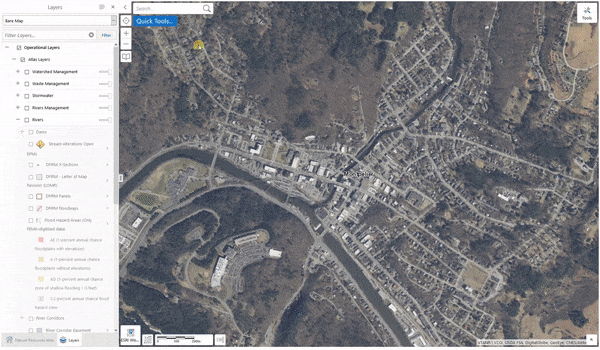
You can use tools such as the Vermont Interactive Map viewer to measure a parcel’s GIS acreage. We say “GIS acreage” as this measurement may be different than what is displayed in a parcel’s joined grand list information. By default, the grand list-joined parcel data published by the Parcel Program displays the acreage for a parcel in its attributes exactly as stated in the grand list. This procedure may be helpful for confirming that the listed grand list acreage for a parcel matches its drawn boundaries.
- Open the Vermont Interactive Map Viewer in your web browser.
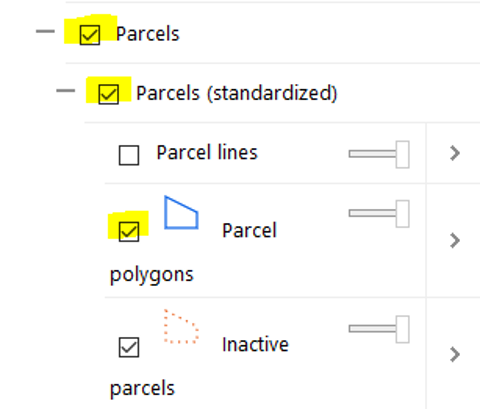
- Turn on the parcel layer(s) and any other layers of interest:
-
- Navigate to the parcel of interest. You can do this by zooming in to the map window, using the "zoom to town" tool under the Navigation tab, and/or searching by town or address in the search bar in the top right and selecting the correct search result.
- Once you have the parcel in your map window, select the Measure tab.
- Click Polygon, set the units to Feet (ft) and Acres (ac), and click the “Enable Snapping” button. The parcel layer(s) should be set as a snapping layer by default.
- Trace the parcel polygon you wish to measure in the map window by clicking once on each of its corner points. When you have the entire parcel traced, double click the first point you traced to close the polygon measurement. This will automatically display the acreage and perimeter of the shape you’ve drawn. Done!
Here's an example of this task:
Users may also use the Vermont Interactive Map Viewer to measure areas within a parcel and print that out as a .pdf for reference. For example:

What can standardized, grand list-joined digital parcel data be used for?
Here are a few examples of how parcel information that is joined to the grand list can be used:
- Expedited property ownership research
- Understanding statewide patterns
- Emergency management, such as in the case of flood mitigation.
- Fiscal impact and real estate analyses on parcel-by-parcel basis by joining other information to parcel data.
- Analysis and communication of public investments. Impacts of public investments may be tracked by viewing changes in assessed value over time.
- Tracking and communication of related policy and permits. Combining parcel data with other spatialized data allows clarification of which policies and permits apply to what property owners where.
- Public notifications can be generated by exporting a spreadsheet of select parcels and associated mailing information within the parcels viewer.
- Land cover analysis to discern how much of a certain land cover type is found within specific properties.
- Land use planning. For example, a town's parcel data can be combined with other map layers such as zoning data, building footprints, waterways, etc.
For Municipalities
How will the initial 3-year (2017-2019) parcel mapping project affect my town?
It depends:
- If your town currently keeps your tax maps up to date and has digital parcel data that reflect those maps: the project funded the update of your data once in a year so that it meets the state data standard which allows joining to your annual grand list submitted to the state. These data should be used for future updates.
- If your town hasn’t updated your maps and/or digital parcel data recently: the project funded the update of your data once in a year so that it meets the state data standard which allows joining to your annual grand list submitted to the state. These data should be used for future updates.
- If your town doesn’t have tax maps or doesn’t have digital parcel data: the project funded the creation of your parcel data once in a year so that it meets the state data standard which allows joining to your annual grand list submitted to the state. These data should be used for future updates.
- Please note that this project did not fund the creation of paper tax maps or vendor-supplied online mapping applications.
Did municipal officials have the chance to review the parcel project data before it was published?
Yes, in phases 2 and 3. After a vendor hadsubmitted their preliminary data to the state, either the vendor or VCGI created a web-based map viewer for the town's parcel contact to review the information. Parcels with missing SPAN information were symbolized in a specific way to aid in obtaining their SPAN information, which may have then been submitted by the town to the vendor for incorporation. Inactive parcels should also have been reviewed at this time. Towns were given 3 weeks to review the parcel data, and vendors were expected to incorporate changes that are submitted to them before the data is published as part of the statewide "standardized" layer.

What should a town look for when reviewing data?
Relative to a grand list submitted to the state for that respective year, a town should check for:
- Parcels with missing SPAN information. In other words, a municipality's grand list contains fewer entries than mapped parcels in their town. This may be due to how information for "inactive" and or tax exempt parcels is managed (e.g. not submitting it with the grand list). In these instances, make sure that as many parcels with missing SPAN information as are known can be provided to the vendor for incorporation, and that all inactive parcels are cataloged.
- Improperly classified inactive parcels. Check to make sure that mapped subdivisions are not classified as "active" parcels if they remain held by the owner of an abutting parcel. These would be classified as "inactive".
- 2 or more parcels with the same SPAN. This may occur in Towns with Federal lands, for example, which may not be submitted along with the Statewide grand list.
- Misinterpretation of "exempt", "match", and/or "unmatched". The parcel data standard confusingly has options for classing features as "exempt", which refers to its grand list match status, not its Tax liability.
- Cues for Future Improvements. Digital parcel data may be derived from past versions that were either not created with or verified relative to high resolution orthophotography and lidar data that is now available throughout Vermont. Moreover, digital parcel data created in the project when projected over an aerial photography may be the first time that a town has seen their parcels displayed in such a way. In these cases the visual alignment of some parcels may not match their location in reality (or to the aerial image) to a severe degree. While parcel data is not a ground survey, and the parcel project does not set out to modify linework, towns should make note of severe issues with spatial accuracy of their parcel data to help guide future map improvements to be carried out in subsequent updates and with the aid of additional evidence from ground surveys.
What should a town do once they have gone through the parcel mapping project/a GIS update?
First, check the status and nature of your municipalities' data that we have available via the Town Mapping Status app. This tool reflects the most recently published data we've received from your town, typically as submitted by your map vendor.
Once a municipality has participated in the statewide parcel mapping project, you now have a digital GIS dataset of your parcels that meets the state standard and is therefore joinable to your grand list via the SPAN number. It provides a base dataset on which future updates can be made, whether that work is performed by a vendor, a municipality, or a combination of both. These data are viewable and editable with GIS programs, some of which are freely available. If you are unsure where to access an editable version of your municipalities' standardized parcel data, please contact VCGI's parcel program staff.
Subsequent GIS updates for towns as submitted to and published by VCGI are adherent to the parcel data standard, and should be maintained by the Town in compliance with the standard moving forward (e.g., maintain SPAN use for all parcels, etc.)
You can find a guide and template for issuing an RFP for parcel mapping services here. There is language in that document that guides a mapping vendor on how to maintain standardization and therefore grand-list joinable status. If already present, you should consider adding this parcel data standard language to your existing vendor contracts. You can also review VCGI's guidance for how we will work with map vendors in the ongoing parcel program.
If you are of a municipality that wishes to update your standardized parcel data and maintain adherence to the standard in subsequent annual updates, please contact VCGI's parcel program staff. We will likely be able to find a solution for this workflow.
VCGI is working with the Tax Department's District Advisors to coordinate the notification of a municipalities' annual parcel updates, general mapping practices, and more.
We are also working with GIS staff at Vermont's 11 regional planning commissions to ensure our notification of their receipt of annual parcel data updates if and when they occur.
Lastly, we are working with mapping vendors, including those who have participated in the statewide parcel mapping project, to ensure that their data maintains the parcel data standard.
For any further questions, please contact VCGI's parcel program staff.
What is the longer-term plan for maintaining digital parcel data?
The Statewide Property Parcel Mapping Project Report presented to the state legislature in 2019 contains five recommendations to aid the long-term upkeep of a comprehensive, updated, and reliable standardized digital parcel dataset for Vermont. These include:
- The creation of a single statewide online survey library for digital copies of survey plats
- Requiring the recording of plats for changes in property lines and subdivisions
- The integration of parcel data with property information management system software
- A maintenance plan with shared state and local responsibilities, and
- Transitioning the Parcel Program from VTrans to the Vermont Center for Geographic Information
Included recommendations are to encourage improvements and normalization within the State-required grand list, normalizing the tracking of inactive parcels and condominiums / unlanded buildings, improving how property transfer returns are recorded and submitted to the Tax Department by municipalities, improving the ease of public access to parcel data, adding feature-level metadata to parcel data, adding easements to parcel data, developing and maintaining an online Quality Control (QC) tool, and considering a statewide parcel fabric.
Some of these recommendations, such as the survey library combined with a requirement for it to be populated with recorded plats of line adjustments, could provide the basis for municipalities, their vendors, and or the state to maintain parcel linework updates. Standardized parcel data, being joined with SPAN numbers, allows the regular updating of ownership information when fed with weekly property transfer data that also includes SPAN information.
The combination of these improvements sketch a vast improvement in the quality, coverage, availability, current relevance, and usefulness of a statewide parcel dataset for Vermont.
For Mapping Professionals
What is the VT GIS parcel data standard?
The VT GIS parcel data standard clarifies the technical specifications of the contents, structure, and formatting of Vermont parcel data such that it reflects recording practices and permits joining with the statewide grand list. It is one of other standards and guidelines documents crafted to ensure that Vermont GIS (VGIS) data is compatible with and useful to others in the VT GIS community. If you have questions about the parcel data standard, please contact VCGI's parcel program technical lead.
What is the difference between an "active" and an "inactive" parcel?
Sometimes, when two or more abutting parcels have the same owner, one of those parcels is considered the main parcel, or active parcel, to which a single tax bill is associated with all of the abutting parcels under the same ownership. The others are considered "inactive". In these cases and for mapping purposes specified by the VT GIS parcel data standard, all of the abutting parcels under the same ownership are collectively modeled as one parcel representing the cumulative boundary, with attribution of the active parcel in the active parcels data layer. Attribution of the inactive parcels is to be placed in the inactive parcel layer.
An inactive parcel becomes active when a recorded property transfer for that parcel occurs. Municipalites tend to track inactive parcels differently, as there is no formally defined practice or requirement for their upkeep. That said, be sure to work with your municipality to confirm if and how they track them, and to incorporate that information if available in the active and inactive parcel layers respectively for that town.

How can map vendors participate in the ongoing parcel maintenance program?
The parcel “program” refers to the ongoing maintenance effort for publishing grand list-joined municipal parcel data in Vermont beyond the project and beginning in statewide grand list year 2019. These data are intended to update and overwrite parcel data collected and published as part of the parcel project up through December 2019.
Unlike the parcel project, there is no state funding available for payments to vendors for GIS mapping services as part of the parcel program. Contracts for map products and services are the responsibility of each municipality. Although there will be no contracts administered by the state for municipal GIS parcel data maintenance and participation in the program is voluntary, map vendors are encouraged to share parcel data updates for their respective towns with VCGI for incorporation into the statewide dataset. One of the advantages of doing so for both towns and vendors is that applications built to view grand list-joined parcel data will continue to be provided for all towns free of charge (e.g. the VT Parcel Viewer, ANR Atlas, etc.), and data updates will continue to be published to these viewers as they are received.
An overview of VCGI's guidance and policy for working with map vendors in the ongoing parcel maintenance program can be found here. Feel free to reach out to us with any comments or questions.
How do map vendors submit parcel geometry updates to VCGI for inclusion in the statewide layer?
Please use the Municipal Parcel Data Update Submission Web Form available from the Share Map Data page at vcgi.vermont.gov. Enter the required and relevant fields with one entry per each municipality, and attach a .zip file of the respective update for that town. You will receive an email notification upon successful submittal. VCGI will then review the updated geometry, reach out to the submitter if we have questions, and add the updates to the statewide layer on a weekly rolling basis when ready for publishing. The GIS Date of submitted and published updates, as well as submitter information, are available to view in the VT Parcel Program Status application. Learn more about when parcel updates are published here.
Questions?
Contact a parcel program team member:
Dylan Broderick at 802-272-7344
Chaveli Miles at 802-279-6384