- What is (airborne) lidar?
- What kinds of data products are made from lidar?
- What are example uses of lidar-derived data products?
- Where can I view an overview of lidar products and where to access them?
- Where can I download and stream lidar-derived data products?
- Where can I view/download raw point cloud data?
- How do I convert LAZ files to LAS files?
- Is it possible to batch download an entire lidar-derived data product collection?
- In what resolution(s) are lidar data available?
- How can I find what the latest/greatest lidar collection is for an area of Vermont?
- How do I find the flight date of available lidar data in an area of interest?
- What are the differences in hydro treatments in lidar-derived DEM's?
- Can I obtain the height above ground in meters for a point location using the nDSM service?
What is (airborne) lidar?
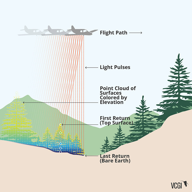
From USGS:
Light Detection and Ranging (LIDAR) is a technology similar to RADAR that can be used to create high-resolution digital elevation models (DEMs) with vertical accuracy as good as 10 cm. LIDAR equipment, which includes a laser scanner, a Global Positioning System (GPS), and an Inertial Navigation System (INS), is generally mounted on a small aircraft. The laser scanner transmits brief laser pulses to the ground surface, from which they are reflected or scattered back to the laser scanner. Detecting the returning pulses, the equipment records the time that it took for them to go from the laser scanner to the ground and back. The distance between the laser scanner and the ground is then calculated based on the speed of light.
While flying, the airplane’s position is determined using GPS, and the direction of the laser pulses are determined using the INS. Because one laser pulse may reflect back from multiple surfaces, such as the top of a tree, a house, and the ground surface, there are multiple returns from each pulse that can be used to map such things as the top of the tree canopy, buildings, and the ground.
Post-processing is used to differentiate between these multiple returns to determine the bare-earth surface. Using the combined information from the laser scanner, the GPS, and the INS, very accurate, closely spaced (typically 1 per square meter) X, Y, Z coordinates are determined from which a DEM is be made.
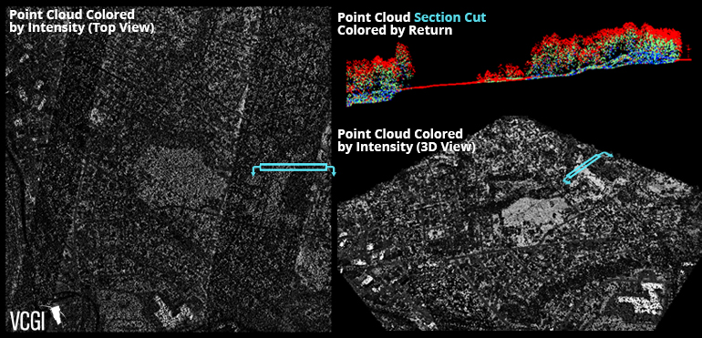
An example of the raw data generated by airborne lidar, known as a "point cloud", is depicted here:
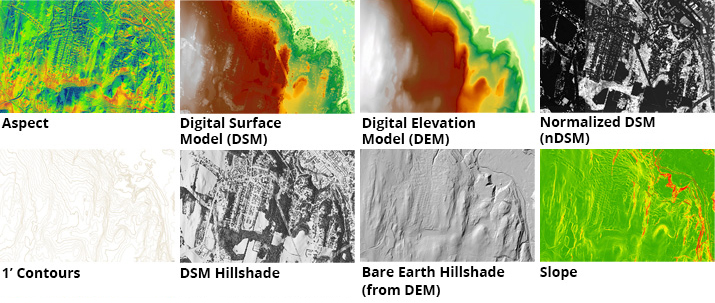
What kinds of data products are made from lidar ?
People may ask "how can I use some of that lidar data", and it is likely what they are asking are for uses of specific lidar-derived data products. These are made from the raw point cloud data, and are made available as "derivative" products. These may inclulde digital elevation models (DEM's), which represent the earth's surface with the structures and vegetation removed, to normalized digital surface models or nDSM's, which represent the difference between the first and last returns, effectively displaying the height of attributes such as buildings.
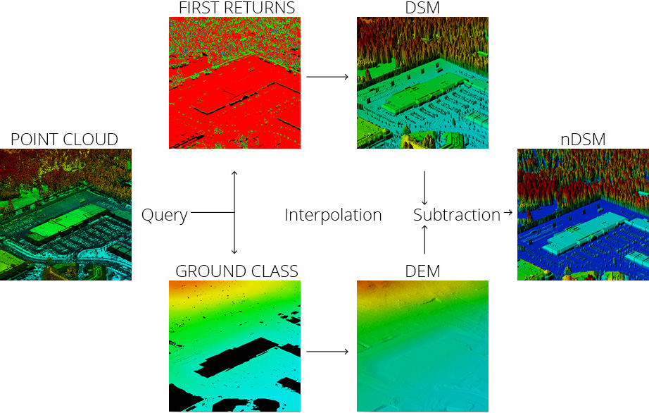
The process of moving from the point cloud to derivative products. Image courtesy of UVM's Spatial Analysis Lab.
Other derivative products include contours, aspect or the prevailing direction of slope, and percentage slope datasets:
What are example uses of lidar-derived data products?
The short answer is: too many to mention! In addition to those listed on the lidar program page, we are are often made aware of unanticipated uses. As of 2019, high resolution elevation data are available statewide. This enables a variety of uses across disciplines and geographic scales. For example, the Vermont Geological Survey has shared the following example:

Lidar-derived products used to clarify the extent of former Glacial Lake Winooski in what is now Central Vermont. Image: Colin Dowey and George Springston, Vermont Geological Survey / ANR
Another example comes from the Water Management Division of the Agency of Natural Resources, who uses the fine-grain detail of lidar-derived elevation products to better understand wetlands across Vermont:
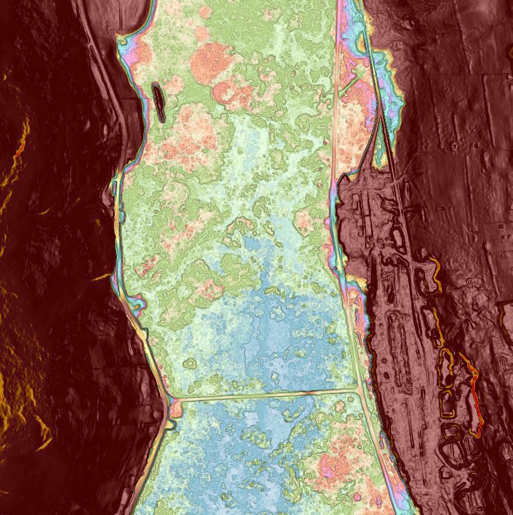
An example of custom symbology used to display small changes in elevation that influence the form and function of wetlands, in this case a wetland in West Rutland. Different colors represent slight changes in topography. Image: Charlie Hohn, Department of Environmental Conservation / ANR
If you have an interesting example use of our lidar data, get in touch with us, we'd love to know.
Where can I view an overview of lidar products and how to access them?
Please see the .pdf slideshow available here, or the accompanying video recording here.
Where can I download and stream lidar-derived data products?
Elevation products such as contours, digital elevation models and more in GIS format are found at the Vermont Open Geodata Portal's elevation page. A map-based way of downloading the most current version of these datasets is provided by the Vermont Lidar Finder.
Where can I view/download raw point cloud data?
USGS provides a web map tool for downloading raw lidar point cloud data in .laz/.las format. This application allows you to search and download point cloud data by geographic extent and product. See the "How-to" button near the top of the page for instructions, if needed.
USGS also provides a browser-based way to view and download our raw lidar point cloud data in multiple formats. Documentation is available here.
How do I convert LAZ files to LAS files?
You may use the open source LASzip application available here. USGS provides a short tutorial on how to use this tool here.
Is it possible to batch download an entire lidar-derived data product collection?
Yes. A web folder of all the individual tiles for a respective dataset may be found linked from the right-hand side of the tiled-data download tool. These tiled data download tools can be found for their respective dataset from either the data catalog on the elevation page at the VT Open Geodata Portal, or from a popup window in the Vermont Lidar Finder (there it will be a link that says "Download by Tile"). These links bring you to a tile data download page with a variant of this in the top right corner:
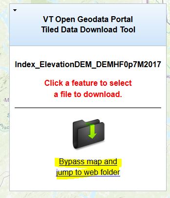
This leads to a web folder were each individual data file lives. Once there, a tutorial that explains how to use a Chrome browser extension to batch download these files is linked here.
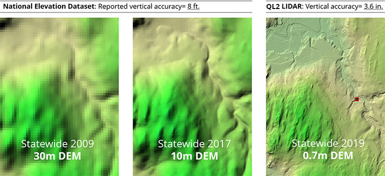
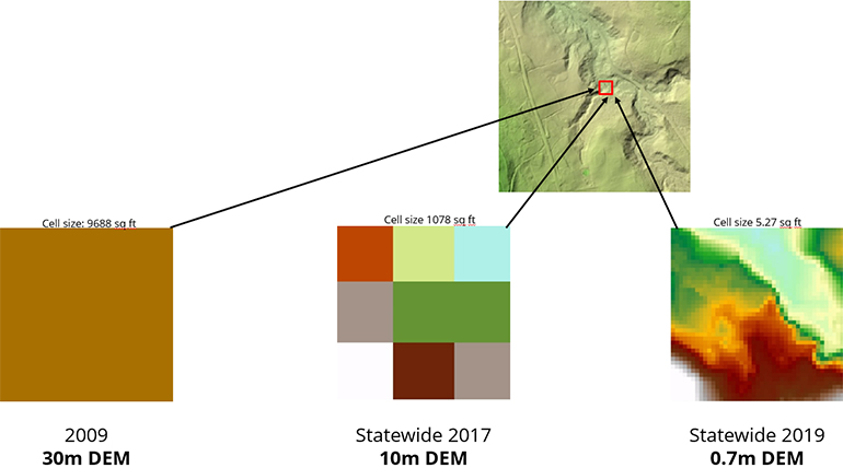
In what resolution(s) are lidar data available?
The resolution of lidar data in Vermont has improved. The first collection from 2004 was "QL4" or quality level 4, representing 3.2 meter resolution. QL3 collections were produced through 2012, representing 1, 1.6, and 2 meter resolutions. From 2013 through 2017, lidar collections were at quality level 2 or QL2, representing 0.7 meter resolution. An explanation of lidar quality levels can be found in the USGS lidar base specification, and in shorter form here. Lidar-derived elevation products are sortable by resolution ("QL" level) at the elevation page on the Open Geodata Portal. The following images depict how resolution has improved:
How can I find what the latest/greatest lidar collection is for an area of Vermont?
The Vermont Lidar Status Viewer displays the geographic extent and characteristics of the most recent and best available lidar collections organized by the lidar program throughout the state.
How do I find the flight date of available lidar data in an area of interest?
Flight information for a particular lidar-derived dataset can be found in that item's metadata, and more specifically, in the vendor report for that respective collection. Both are available from the Open Geodata Portal, with vendor reports linked from the bottom of the elevation page.
What are the differences in hydro treatments of Lidar-derived DEM's?
USGS has provided an overview of the differences between processing LiDAR with regards to hydrography. Each of these options, "Hydro Flattening", "Hydro Enforcement" and "Hydro Conditioning" are explained in the powerpoint file linked here.
Can I obtain the height above ground in meters for a point location using the nDSM service?
Yes, with caveats:
- First, this method applies to and assumes you are using ArcGIS Pro. It is untested with other platforms.
- Second, only actual height values between 1 and 47 meters above ground can be returned (>99% of all locations in VT). Actual height values lower or higher than this range are not able to be identified as they are not within the remapping range used to create the service itself. This means that objects higher than 47 meters above ground in the real world will still only return a pixel height value of 47 (meters). It is a limitation of the source data and presentation of a visually coherent statewide data layer.
Using ArcGIS Pro, perform the following:
- Load the nDSM service into a project
- Right-click the layer in the table of contents and uncheck "Use Service Cache":
![]()
- With the nDSM layer hightlighted in the table of contents, selec the Data menu tab
- Select Processing Templates-->None from the drop-down menu:
![]()
- This will now remove the symbology applied to the cached image service and allow one to identify pixel values for objects with heights between 1 and 47 meters above ground:
![]()
Note: This method of toggling-off a service’s cache and processing template also allows one to re-symbolize a service as they wish, and with Dynamic Range Adjustment (DRA) also applied to more easily view values within a specific area of interest.