VCGI has been working with our partners in the Enterprise GIS Consortium to prepare for updated datums and corresponding changes to Vermont's State Plane Coordinate System (SPCS). This post aims to clarify the impacts of proposed changes to Vermont's Coordinate System, and particularly for those who work with the foot as a unit of measure.
In a Nutshell
- Current Vermont statute specifies use of the U.S. survey foot--if one uses the foot as a unit of measure--when working in the legacy Vermont Coordinate System 1927 and the Vermont Coordinate System 1983, the latter being the current state plane coordinate system.
- The U.S. Survey Foot, however, will be deprecated on December 31, 2022, per NIST and NOAA via this Federal Register Notice.
- Deprecation does not mean that the sft will cease to exist or cease to be used. Instead, the U.S. survey foot will continue to be used as long as the Vermont State Plane Coordinate System 1983 and the legacy 1927 system is used.
- The 1983 system will remain the official VTSPCS until at least 2025.
- It is only after release of the updated Vermont State Plane Coordinate System by NGS sometime in 2025 and its subsequent use that the international foot must be used instead of the U.S. survey foot--if one needs to work in feet, that is.
- Metric (SI) users are unaffected by any of these changes in units of measure.
- Vermont statute pertaining to the Vermont Coordinate System will be modified to reflect all of the above. Proposed changes to it that have been worked out among Vermont's Enterprise GIS Consortium, NGS, and with input from Vermont's surveying community, are to be considered by the legislature during the 2023-2024 legislative session.
Abbreviations and Acronyms
The following terms are found throughout:
- sft - U.S. Survey Foot. Defined as a fraction of 1 ft = 1200/3937 meters
- ift - International Foot. Defined as 1 ft = 0.3048 m exactly.
- NSRS - National Spatial Reference System
- SPCS - State Plane Coordinate System
- NATRF2022 - North American Terrestrial Reference Frame of 2022, a new datum
- NAD 83 / NAVD 88 - Current horizontal and vertical datums respectively
- NGS - National Geodetic Survey
- NOAA - National Oceanic and Atmospheric Administration
- NIST - National Institute of Standards and Technology
- VTSPCS 83 - Vermont State Plane Coordinate System 1983. The current official Vermont Coordinate System per Vermont Statute, until release of VTSPCS by NGS.
- VTSPCS 27 - Vermont State Plane Coordinate System 1927. An earlier, now "legacy" Vermont Coordinate System per Vermont Statute.
- VTSPCS - Vermont State Plane Coordinate System. The future official Vermont Coordinate System, defined as the most recent system of plane coordinates established by NGS. Not expected to be released until 2025.
- SI - International System of Units. Also known as the metric system.
Deprecation of the U.S. Survey Foot, Use of the International Foot
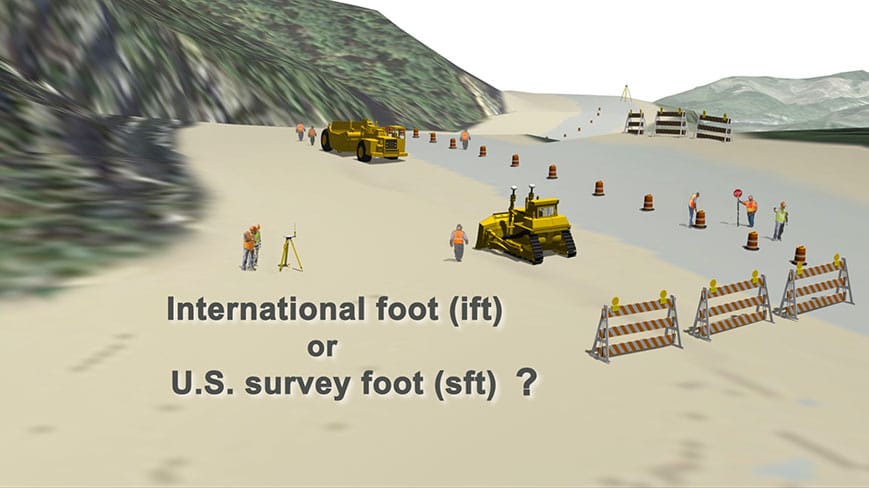
Did you know that there are two different definitions of the "foot"? It may not be obvious, at least to those of us lucky enough to use the metric system in our work. The U.S. Survey Foot and International Foot are very close but not exactly the same. That small difference adds up over large distances, contributes to ongoing confusion, and given the opportunity of updating the NSRS, its datums, and subsequent SPCS's nationwide, NOAA and partners have organized to finally officially deprecate the U.S. Survey Foot as of December 31, 2022. This 2 1/2 minute video provides an overview of the issue:
The above video produced by NOAA/National Geodetic Survey (NGS) explains the difference between the U.S. survey foot (sft) and the international foot (ift), as well as the importance of this distinction when working with map projections and long distances. The U.S. survey foot will be deprecated on December 31, 2022, however, it will remain supported and in use when associated with the "legacy" Vermont State Plane Coordinate System 1983. The updated Vermont State Plane Coordinate System, when released by NGS, will require use of the international foot when the foot is used as a unit of measure.
Proposed Updates to the Vermont State Plane Coordinate System (VTSPCS)
NGS intended to rollout the new State Plane Coordinate Systems at the same time as the deprecation of the U.S. Survey Foot. The complexity of the updated NSRS and related SPCS's however, prevented their joint release and has resulted in a delay of the modernized NSRS.
The U.S. Survey Foot is specified in Vermont's and many other states' statues in relation with state plane coordinate systems. As this aspect is changing in 2023 even without the release of the updated VTSPCS, it calls for a revision of statute to accurately reflect both elements.
Proposed changes to Vermont's Coordinate System are viewable below. Further notice will be given if and when their final form is accepted. For updates, see the current bill S.154 - An act relating to the Vermont State Plane Coordinate System.
What To Do Between January 1, 2023 and the Release of the Updated VTSPCS When Working In Feet?
The following guidance from NGS applies (emphasis added):
You should continue to use the U.S. survey foot (sft) for SPCS 83 after 2022. You
should NOT make the switch to the international foot (ift) definition while using SPCS 83
(or SPCS 27). States currently using the sft for SPCS 83 should continue to do so. [Note: This includes Vermont.]
The ift will be used for all zones in every state for SPCS2022, and every other component of
the National Spatial Reference System (NSRS), but that won’t be implemented until
2025....
NGS will always support the sft for SPCS 83 in states that have officially adopted the sft for
SPCS 83, even after SPCS2022 has been implemented. The same is true for SPCS 27
in all states....
People will continue to use SPCS 83 at least until SPCS2022 is rolled out in 2025.
Those states using the sft for SPCS 83 should continue to do so. That means they
should continue to use the sft in their equipment and associated software (such as GIS
and CAD)....
It’s important to also point out that although NGS will always support the sft, it will only
do that for the legacy SPCS 27 and 83 systems. Once Modernization is done, NGS will
not provide any tools (like OPUS) which allow users to work within NAD 83. At best,
NGS will allow users to find old NAD 83 coordinates, and use NCAT to transform to/from
NAD 83. But, in general, NGS will not support NAD 83 after modernization.
In summary, if you must use the foot as a unit of measure, keep using the sft when using SPCS83, which will remain the Vermont State Plane Coordinate System until at least 2025. After release of the updated VTSPCS, any project then using that system must use the ift when using the foot as a unit of measure. Metric units remain unaffected by any of these changes.
What About Software, Coordinate Conversions and Transformations?
The U.S. Survey foot is defined as a fraction in which 1 ft = 1200/3937 meters. The international foot (ift) is defined as 1 ft = 0.3048 m exactly. Conversion of meters to international feet is accomplished by multiplying the meters by 3.280839895. Users of surveying instruments and GPS units should take caution to note which version of the foot is being used, and choose among them accordingly depending on the version of SPCS being used.
The updated VTSPCS is not yet released, and software and equipment manufacturers will decide how to add and reference the new system in their products when available. We expect a new EPSG parameter to be issued with the release of the updated VTSPCS, which will differ from the current VT SPCS83 of EPSG:32145. We will post widely about this when available.
NGS reminds users that conversion tools such as NCAT will continue to be of use:
The NGS Coordinate Conversion and Transformation Tool, or NCAT, allows users to
easily convert between different coordinate systems and/or transform between different
NSRS reference frames and/or datums, in a single step. For coordinate conversions,
NCAT allows conversion between lat/long/height, State Plane, UTM, US National Grid,
and geocentric (XYZ) systems. As part of NSRS modernization, NCAT will be updated
to support conversions between existing State Plane and SPCS2022, and NCAT will
continue to support both NAD 27 and 83 (and their associated versions of State Plane).
What Changes Are Expected in the Forthcoming VTSPCS?
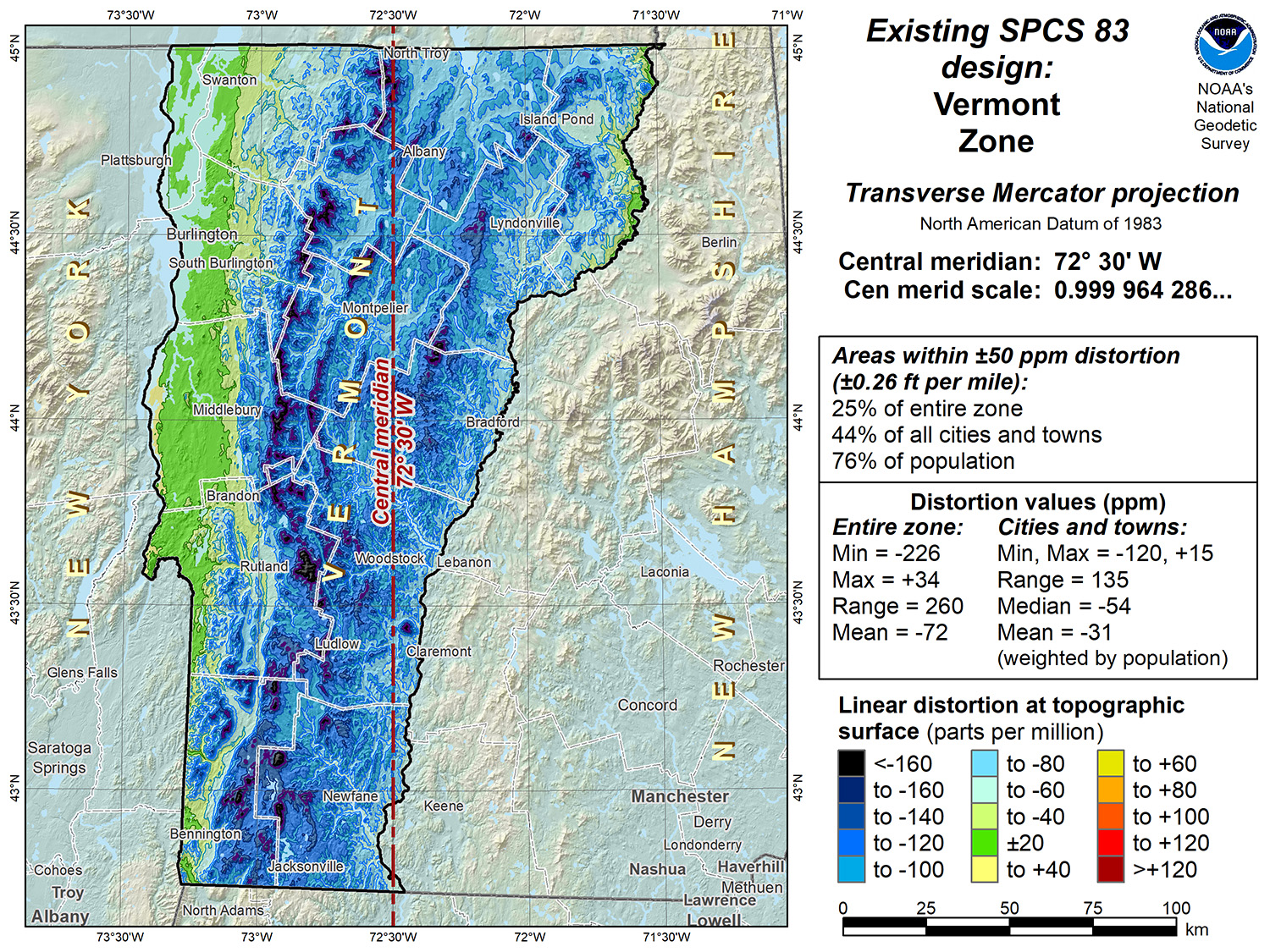
Vermont has accepted NGS' preliminary design for the updated, single-zone Vermont State Plane Coordinate System to be based upon the new horizontal and vertical datums, with one modification to the false easting value.
Overall, the updated VTSPCS will have less linear distortion, and be based upon new datums that address shortcomings of the current NAD83 / NAVD88 datums.
Current VTSPCS 83 Linear Distortion per NGS, based on the NAD83 datum:
Proposed VTSPCS Linear Distortion per NGS, based on the updated NATRF2022 datum. Also note the different Central Meridian:
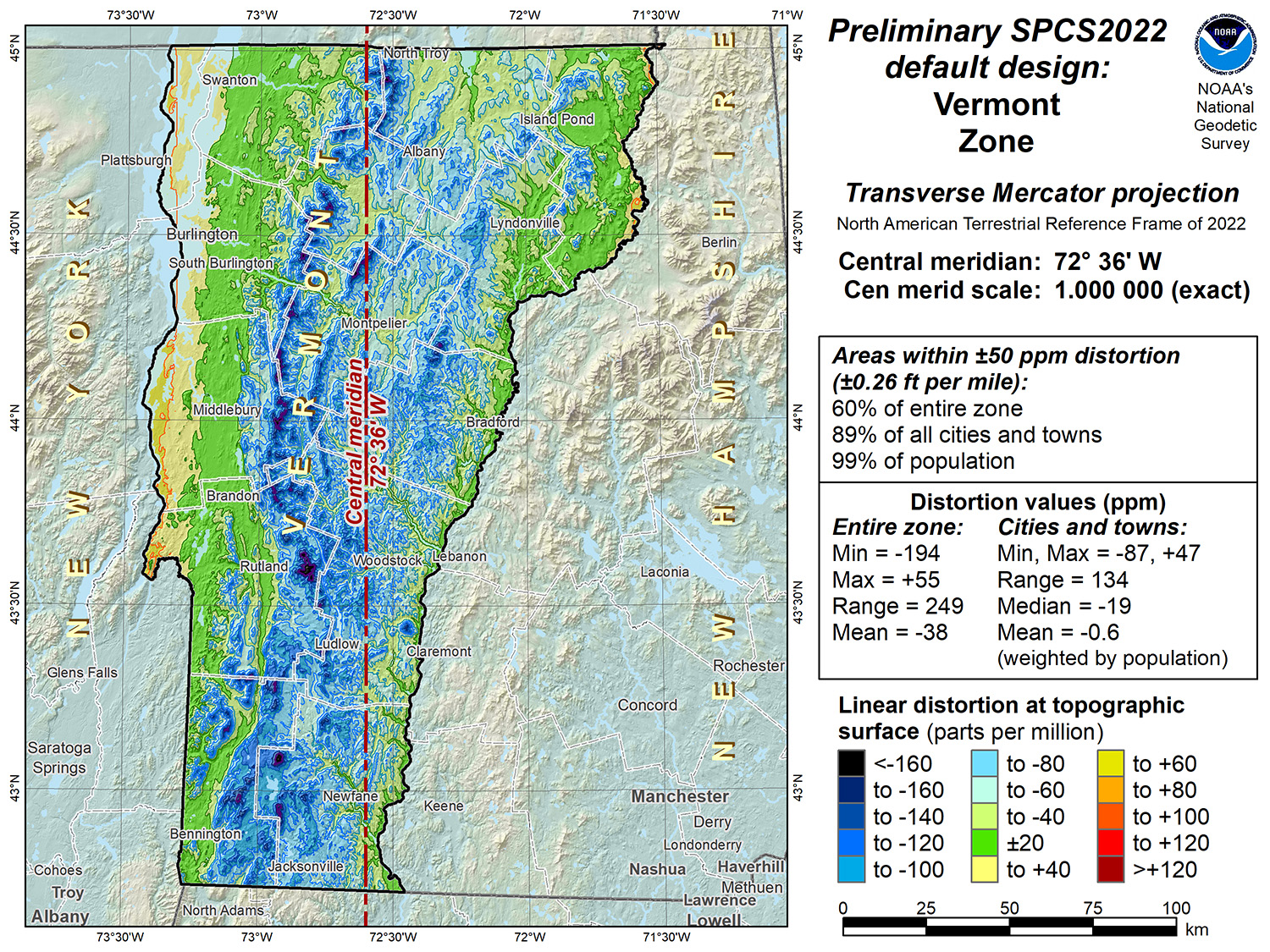
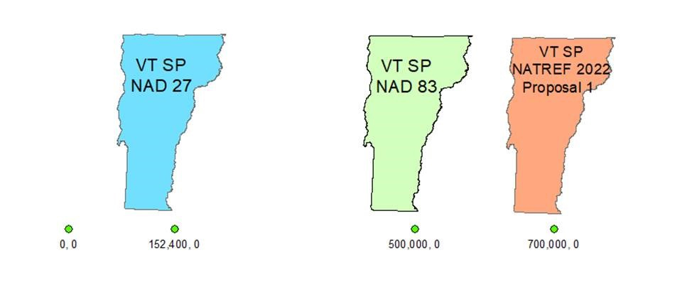
Vermont's updated SPCS will have a false easting value of 700000, 0 to ensure that there are no confusing overlaps between content projected in it versus older, legacy systems with different false easting values.
Vermont's updated SPCS is not expected to be released by NGS until sometime in 2025. You will hear much more from us about what to expect when using the new SPCS in time and as its release date nears.
What About Updates to Vermont's GIS Resources (Orthoimagery, etc.) to Reflect the New SPCS When Released?
VCGI and partners of the Enterprise GIS Consortium have not yet determined a policy and timeline on modifications to existing GIS data when the new VTSPCS is released in 2025. We will post when we do, as well as do our best to clarify which data are in what SPCS and when. Related VT GIS resources such as guidance and standards on Map Coordinate System, Use of Vermont Coordinate System, and Horizontal Datum Conversions will also be updated accordingly.
More Resources
Deprecation of the U.S. Survey Foot - Federal Register Notice - October 2020
Changes Afoot After 2022: State Plane and the Death of the U.S. Survey Foot by Michael Dennis, PhD, PE, PLS of NGS / November 10, 2022 (Powerpoint presentation download link)
Changes Afoot After 2022: State Plane and the Death of the U.S. Survey Foot - Follow Up FAQ's / Q&A / November 10, 2022 (PDF)
New Datums: Replacing NAVD88 and NAD83 - NGS
Vermont Coordinate System - Vermont Statutes Online