Parcel mapping in Vermont is undertaken and overseen by each municipality, who may perform annual map updates on their own or hire vendors to maintain. As part of the Parcel Program, VCGI coordinates the collection of the best available digital parcel data from municipalities and publishes them in a uniform GIS format joined with the Tax Department’s annual grand list. VCGI also develops the data standards, templates, digital parcel mapping guidelines, and guidance resources by which Vermont digital GIS parcel data are organized and made publicly available.
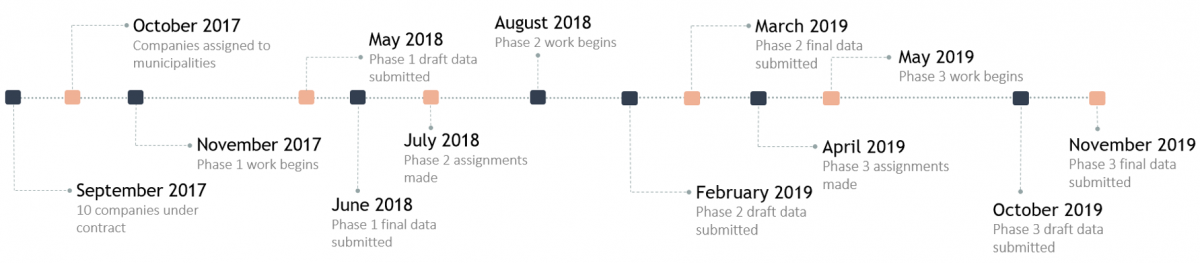
The Parcel Program is an outgrowth of the Statewide Property Mapping Project which included a three-year (2017-2019) funded effort to create or update digital GIS parcel data for all of Vermont’s municipalities. The Project successfully completed that work in December 2019, resulting in a freely available GIS layer for all Vermont municipalities joined with their annual grand list via a parcel’s unique School Property Account Number (SPAN). The parcel Program now supports the ongoing collection and publishing of municipal parcel data in GIS format statewide, continuing to use the SPAN number as a unique parcel identifier.
What is the Statewide Property Parcel Mapping Program?
- The ongoing effort for the publishing of annual grand list-joined digital municipal parcel data throughout Vermont in GIS format that are freely available and useful
- The Program is overseen by VCGI, yet relies on cooperation among towns officials who oversee their grand list and map maintenance and their map vendors in updating and sharing parcel data with VCGI
- Unlike the three-year Parcel Project, there is no state-administered funding for payments to vendors for GIS mapping services. Contracts for map products and services are the responsibility of each municipality. VCGI provides guidance on parcel mapping contracts here.
- While participation in the Parcel Program is voluntary, it is strongly encouraged as existing and new mapping tools that are publicly accessible (e.g. the Vermont Parcel Viewer) will rely upon the statewide parcel data published by VCGI
Why Statewide Property Parcel Mapping?
Digital parcel data support many kinds of mapping and analyses, including but not limited to:
- Providing easily accessible, up-to-date, ownership information that can be related with other mapped information
- Improved grand list maintenance
- Fair and accurate taxation and reappraisal
- Informed community planning and economic development
- Targeted natural resource conservation
- Understanding statewide patterns across multiple criteria
- Providing a spatial container to link other relevant information with (e.g. does a permit apply here?)
Users of parcel data across agencies and jurisdictions are increasingly reliant on the spatial aspects of property ownership to effectively meet public administrative needs. This includes, for example, ensuring access to reliable and current parcel data that reflects municipal grand lists, which in turn is used for other work such as understanding the distribution of resources, supporting correct information for permits, infrastructure projects, planning and targeted investments, the evaluation of publicly funded programs, adequate emergency response, advanced research, and more. See example uses below.
More simply, property ownership is a foundational aspect of our society's organization and function. Having current, comprehensive and available property parcel data is thus a part of this organization and function.
How are parcel data maintained and updates published?
- The Parcel Program relies upon a municipality’s contracted map vendor to share digital parcel updates with VCGI once completed and reviewed by a town.
- Towns and map vendors can see our guidelines for working with VCGI here.
- Updates are incorporated into published parcel data, services, and applications when received from towns and/or their vendors
- For those towns without mapping contractors or capacity, VCGI will update the joined annual grand list made available from the Tax Department, as well as add any line changes documented within the Vermont Land Survey Library. This may likely not be as thorough of an update as performed by a contracted map vendor, which is the recommended practice for towns to receive the attention they may require.
When are parcel data updated?
The short answer:
- Parcel geometry are updated for each town after they are received by VCGI from their updating entity, typically a vendor hired by the town
- Parcel grand list attributes are updated for all towns once every year
For a more detailed explanation, see this FAQ.
What parcel data are not
While statewide, up-to-date digital parcel data are very useful, it is important to note what parcel data are not:
- Parcel data are not a land survey. Instead, they are a reference index of property ownership. Surveys may inform parcel data and ultimately improve them with time, but they are not the same. See the Vermont Land Survey Library for more info on surveys created and submitted to VCGI after January 1, 2020
- Relatedly, parcel data are not perfect in spatial or positional alignment. While spatial accuracy may and should be continually improved, linework may not appear in perfect position when viewed over an aerial photo
- Parcel data do not reflect differences between at-grade ownership and that of below-grade mineral rights (e.g. two deeds for the same parcel)
- In the absence of clearly defined town boundary delineation standards and practices in Vermont, parcel data often do not match town boundaries
- In those towns without contracted map vendors or their own digital map maintainers who share updates with VCGI, parcel data may not be fully reflective of the current status of ownership and/or line changes
All items would ideally be improved in time with subsequent updates on a town-by-town basis and are worth considering by the municipality when prioritizing their annual map updates.
Who should I contact about making changes to parcel data?
- Substantial inaccuracies in boundary lines or grand list attributes should be brought to the attention of the Town Clerk, lister or assessor of the respective town(s) in which they are located
- Keep in mind that parcel data are foremost a reference of ownership, are not a survey, and are typically updated once per year for a given municipality.
How can towns participate in the ongoing parcel program?
There are several ways depending on how a town maintains their parcel maps:
For municipalities with contracted map vendors:
- Continue to obtain and maintain contracts with map vendors for regular parcel data updates, ideally in GIS format with continued use of the unique SPAN number for parcels in addition to local parcel ID’s
- Specify criteria for digital parcel data received from map vendors in your contracts with them, including continued SPAN use, time set aside for reviewing data and checking for discrepancies before it is finalized, and ensuring that data products are delivered to Town upon completion of services
- Request and remind your map vendor to share digital parcel updates with VCGI upon completion
- Use the Vermont Land Survey Library as needed to aid digital parcel updates
- Review and confirm your map vendor with VCGI, particularly if and when it changes
For municipalities who maintain their own digital parcel data:
- Continue to perform regular parcel data maintenance, ideally in GIS format with continued use of the unique SPAN number for parcels in addition to local parcel ID’s
- Consider building upon GIS parcel data completed and available for your town as part of the parcel project
- Voluntarily share annual parcel data updates with VCGI
- Use the Vermont Land Survey Library as needed to aid digital parcel updates
- Use the Vermont Parcel Viewer as needed for viewing shared and published updates
- Review and confirm your mapping practice with VCGI, particularly if and when it changes
For municipalities without map vendors or capacity:
- Strongly consider obtaining and maintaining contracts with map vendors for regular parcel data updates, ideally with GIS vendors capable of producing parcel data standard-compatible data (e.g. SPAN use)
- Parcel mapping guidelines and guidance contract language are provided here
- Follow guidance above for municipalities with contracted map vendors, including reminding them to share digital parcel data updates with VCGI upon completion
- Review and confirm your mapping practice with VCGI, particularly if and when it changes
- Check the status and review existing published parcel data for your town with the Vermont Parcel Viewer
In all cases, applications such as the Vermont Parcel Viewer and Vermont Land Survey Library are free for all municipalities to use in viewing parcel and parcel-related data. Contact VCGI if you have any questions.
Parcel Data Status
- Municipal Parcel Data Status - This tool displays information about the best available parcel data VCGI has received and published for each Vermont municipality, as well as information about their parcel mapping practices. Click on a town for more information and a link to download in GIS format. Spot an error? Contact us and let us know your town’s mapping plans.
An individual town’s data are overwritten as updates are received.
View and Access Parcel Data
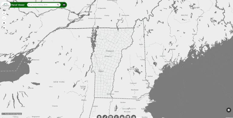
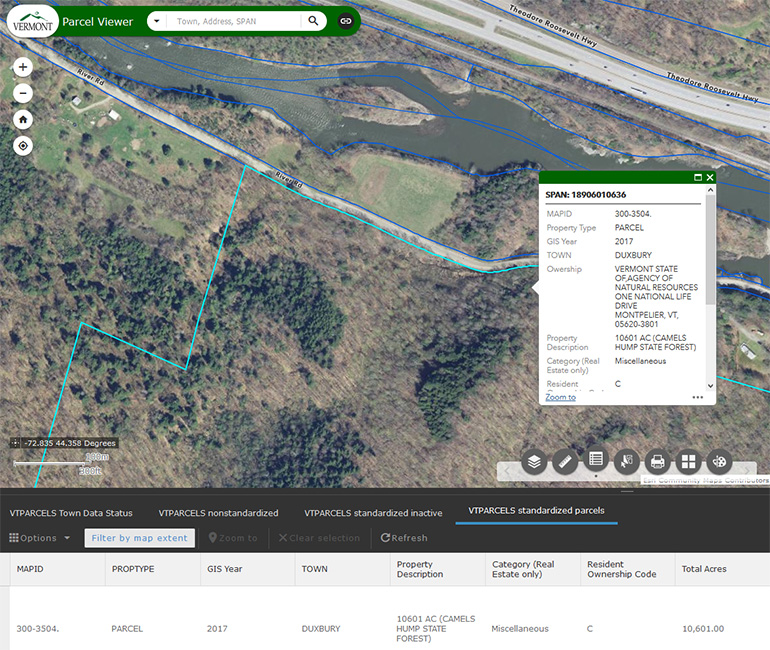
A quick way to view the latest available data is via the Vermont Parcel Viewer. Other applications such as the ANR Atlas, Vermont Interactive Map Viewer, and E911 Viewer also all display the same parcel data.
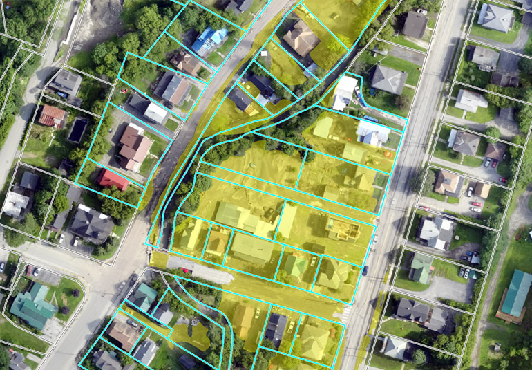
Users can search these applications and locate individual parcels by SPAN or Address. For example, searching for a parcel in the Vermont Parcel Viewer with the search bar and viewing some of its attributes:
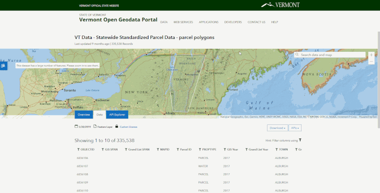
For more advanced uses, all available grand list-joined parcel data is provided to download or stream from links at the Vermont Open Geodata Portal.
At the parcels page on the portal, one can also select and download individual parcels by filtering by a particular attribute value, such as a SPAN number for example:
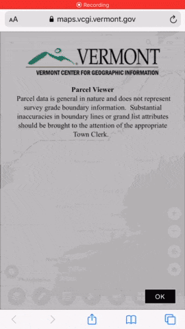
For those in places with cell data access, parcel data can be viewed relative to your location in the field in real-time. This requires enabling location services on your smartphone, and using a tool such as the Vermont Parcel Viewer in your mobile browser.
For offline use, parcel data are able to be downloaded as a .kml file from the VT Open Geodata Portal and imported into a saved-for-offline-use Google My Maps, or as a a different example, can be made into a georeferenced image file along with other data such as orthoimagery to create a field-capable basemap for use in applications such as Avenza.
Example Uses of Standardized Parcel Data
There are multiple uses for grand list-joined, standardized parcel data statewide. The following images depict a few examples.
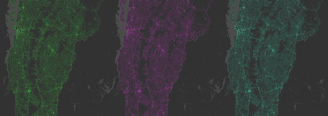
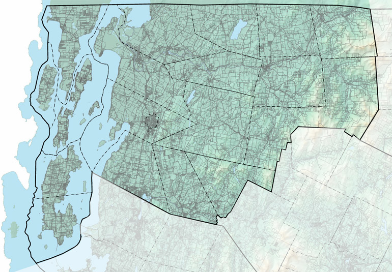
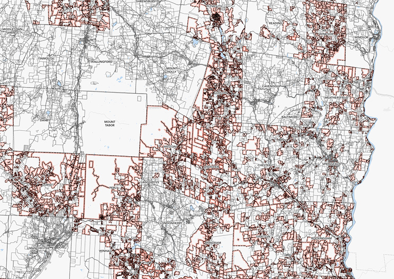
Understanding Statewide Patterns
![]()
A statewide view of land parcelization across Vermont as of December 2019. These patterns reveal human settlement and development patterns, protected areas, physical landmarks, major transportation corridors, and more.
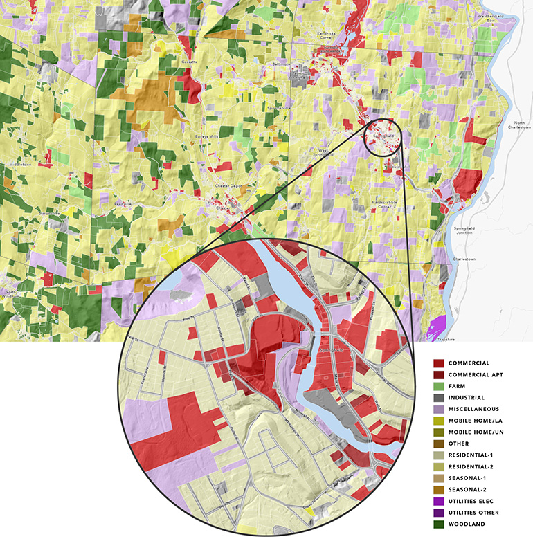
Springfield and surrounding area parcels colored by how the land use category was recorded within the grand list.
Town parcelization itself provides an interesting set of patterns:
Data Improvement and Integration
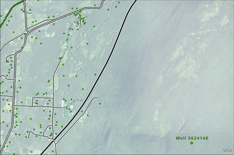
The Vermont Geological Survey is using parcel data for improving the accuracy of known well locations. In the above image, the well to the lower right originally had a questionable location in the Lye Brook Wilderness. By combining the information provided in the well completion report, grand lists, and spatial parcel data the location of the well is improved to match the parcel and structure where it was drilled. Image: Colin Dowey / Vermont Geological Survey
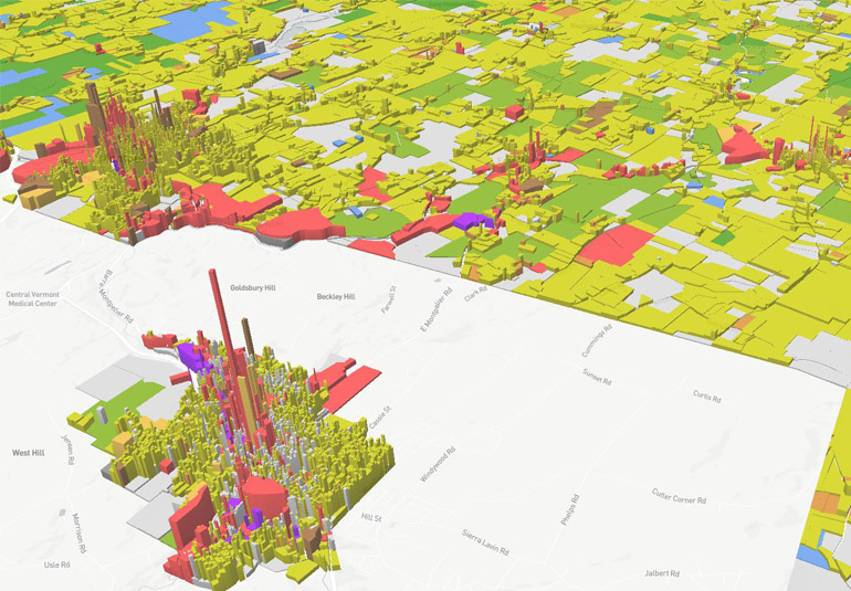
Dynamic Tax Mapping

Parcel geometries are joined with grand list information as collected by the Tax department and can thus display different combinations of these underlying data.
Commerce & Community Development
Standardized, grand-list joined parcel data enables the visualization of grand list fields, such as assessed value. In this image, common level of appraisal-adjusted assessed value of a parcel is shown relative to its size, depicting the normalized assessed value-per-parcel-per-acre, which is helpful for understanding everything from downtown investment to Vermont's economic geography.
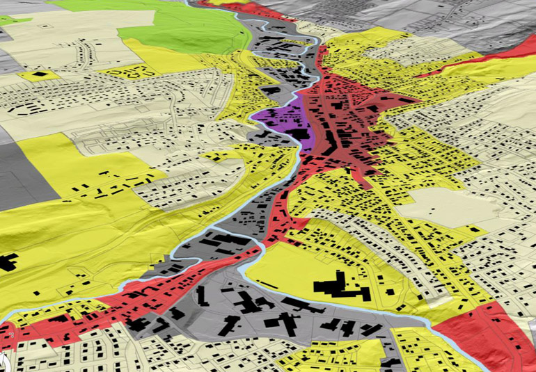
Emergency Planning & Response
Parcel data can be overlaid with other spatial data such as FEMA's national flood hazard layer, clarifying who may be at risk due to extreme weather events as well which owners to contact. Image: UVM Spatial Analysis Lab
Regional Planning
A consistent, comprehensive fabric of parcel data statewide enables Regional Planning Commissions to more effectively do their work by clarifying who owns what where.
Understanding Land Use
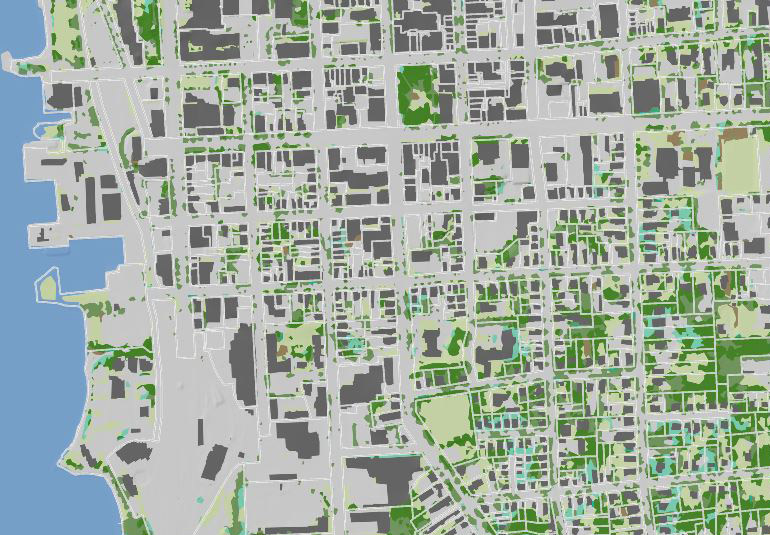
In addition to and combination with other statewide data, parcel data can begin to aid answers to land use and land cover questions in finer detail.
Municipal Planning
Standardized, digital parcel data in GIS format can be used by municipalities during the creation and update of their town plans and other instruments, and aid in understanding the effects of specific policies such as zoning.
Expedited Records Research
Applications that display standardized, grand list-joined parcel data such as the ANR Atlas and the Vermont Parcel Viewer enable far quicker access to parcel information required by multiple business and public administration functions, saving the public time and money in so doing.
Enhanced Mapping Practices
The statewide view enabled by the parcel program allows for a better understanding of mapping and classification practices from town to town and helps to clarify ways forward. For example, differences in how "inactive" parcels are tracked by towns (as shown above in pink) are now able to be visualized.
Related Documents
- Parcel Project Timeline
- List of Mapping Contractors who worked the project [Archive] (PDF) (2017-2019)
- Parcel Program F.A.Q.'s
- Parcel Mapping Advisory Board
- AOT Parcel Project Independent Review (Final)
- Parcel Data and Metadata Templates (comply with Parcel Data Standard v 2.3)
- The Vermont Parcel Data Standard (v. 2.3)
- VT Parcel Data ROI
- VT Parcel Data Lifecycle & Maintenance Plan
- 2018 Statewide Digital Parcel Data Report (PDF)
- FY2021 Parcel Program Plan
History
Vermont’s towns are responsible for determining the value of real estate owned within their boundaries and for taxing those properties. For many years, land ownership information was of interest to the owners, neighbors, and town.
Today, information about land ownership and value is key to many public and private functions: regional planning, transportation planning and construction, state analysis of settlement patterns, taxation equity, and the impact of state programs, just to name a few.
The state of Vermont’s parcel data (from a statewide perspective) has been inconsistent and fragmented. Prior to the Statewide Parcel Mapping Project completed in 2019, some towns had been regular in updating parcel data, but many were either out of date or did not contain elements that make it easier to combine with neighboring towns, and a few towns did not have digital parcel data
Beginning in the fall of 2013, representatives of state agencies, regional planning commissions, nonprofits (VLCT), and professional organizations (VSLS, VALA) began meeting to discuss how to make consistent, up-to-date, statewide parcel data a reality in Vermont. That group eventually became the Enterprise Geospatial Consortium’s (EGC) Parcel Workgroup. The efforts of that group and leadership at the Agency of Transportation and the Agency of Commerce and Community Development resulted in the Transportation Bill passed in 2016 by the Vermont Legislature containing language to create the Program (link to statute).
Funded by the Federal Highway Program and as the initial phase of the longer-term Vermont Parcel Program, the Statewide Parcel Mapping Project (2017-2019) created or updated the digital GIS parcel data for all of Vermont's municipalities in three phases over a three-year period.
The Parcel Program is an effort for maintaining ongoing access to useful digital parcel data statewide set forth by the funded phase of the Parcel Project.
Questions?
Contact a parcel program team member: